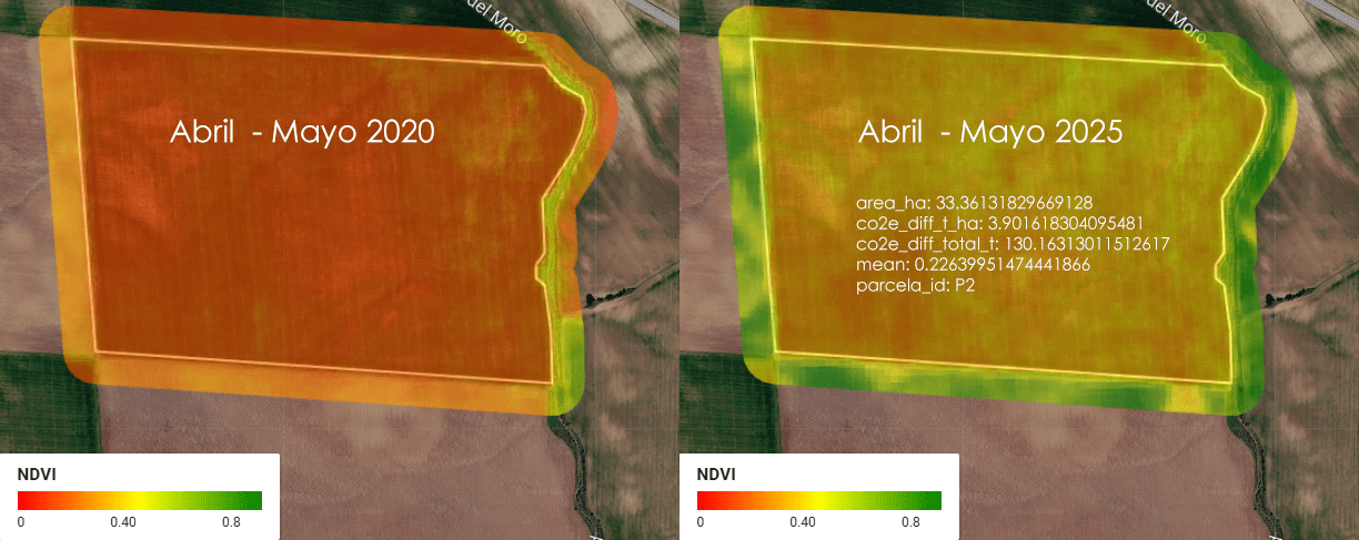
Imagina una empresa que se llama ACME. ACME es dueña de 5 parcelas de tierra en Almendralejo, Extremadura, España, donde se cultiva cereal (trigo, cebada, ese tipo de cosas). Entre las 5 parcelas, ACME tiene un total de 1.52 km² de tierra — para que te hagas una idea, eso es más o menos el tamaño de 300 campos de fútbol (a rzón de aproximadamente media hectárea por cada campo).
Category Archives: energia
SolarScope: cuando el catastro, el LiDAR y el sol se sientan a la misma mesa
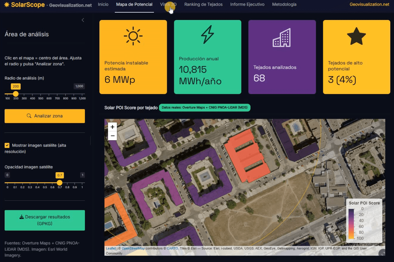
Llevo unos días dándole vueltas a una idea que, en el fondo, es bastante sencilla: si tenemos la huella de cada edificio, su altura y un modelo digital de superficies de alta resolución, ¿por qué seguimos viendo estudios de potencial solar que tratan los tejados como manchas homogéneas sobre un mapa? De esa pregunta, y de unas cuantas sesiones intensas de R, ha salido SolarScope, una aplicación Shiny que estoy desarrollando para hacer scoring de potencial fotovoltaico tejado a tejado, con datos abiertos y un flujo que se puede reproducir tanto en España como en Estados Unidos.
Aventuras y desventuras de un geógrafo en “desarrollo”

La cartografía siempre ha sido un oficio de precisión, paciencia y criterio espacial. Durante años, el flujo de trabajo de cualquier geógrafo pasaba inevitablemente por entornos de escritorio como ArcGIS Pro o QGIS: cargar capas, ajustar simbología, exportar mapas. Herramientas sólidas, probadas, indispensables. Pero algo está cambiando.
Cada vez más, el análisis espacial ocurre en la nube, en navegadores, en entornos de código. En anteriores post habéis visto algunos test/ideas/aplicaciones que he desarrollado con Javascript Google Earth Engine, que procesa imágenes satelitales a escala planetaria sin mover un solo archivo. Deck.gl y Maplibre renderizan millones de puntos en 3D directamente en el navegador. React convierte un mapa en una aplicación interactiva con pocas líneas de código.
Precision Elevation Data for Forest Giants: LiDAR vs ETH Global Canopy Height in Mata do Buçaco (Portugal)

High‑resolution elevation data underpins almost every spatial analysis we do in GIS—especially in forests where vertical structure defines habitat, biomass, wind exposure, fire behavior, hydrology, and the microclimates that sustain rare species. In rugged or densely vegetated environments, a coarse or biased elevation model propagates error everywhere: orthorectification drifts, hillshades mislead, slope/aspect misclassify, and canopy metrics saturate. The result is decisions made on blurred terrain that hides the very patterns we seek to manage. Precision elevation—derived from airborne LiDAR (Light Detection and Ranging)—solves this by separating the ground from the vegetation and delivering both a bare‑earth Digital Terrain Model (DTM) and a Digital Surface Model (DSM). Subtracting DTM from DSM gives a Canopy Height Model (DHM) that captures the true vertical architecture of the forest at sub‑meter resolution.
Urban Heat Islands, Trees, and Climate Justice in the Anthropocene: A Remote Sensing-Based Reflection

In recent years, the need to understand the urban environment has grown more urgent than ever. Climate change is not an abstract future scenario; it is already here, reshaping our cities day by day. Among the many phenomena that demand our attention, the Urban Heat Island (UHI) effect stands out—not only for its environmental and public health impacts but also for its socio-political implications. Through satellite imagery and remote sensing, we can now visualize and quantify these dynamics with increasing precision. This post reflects on such an analysis I conducted using LANDSAT 8 imagery (Scene ID: LC08_L2SP_201032_20250328_20250401_02_T1, Date Acquired: 2025/03/28), and discusses the findings in the broader context of urban planning, climate justice, and the urgent need to protect urban vegetation.
Measuring moisture: Normalized Difference Moisture Index (NDMI) Sentinel-2 2022

I am here in front of my desktop and I wonder how to take advantage of Sentinel Hub for tracking up moisture in a random plot anywhere in the world. Has it been irrigated at the right time for the type of crop? How has rainfall been affected over the analysis time? How has the use of certain fertilisers affected it? Has it positively affected production?. Let’s take a closer look.
Marathon à Nantes 2022: CHECKED!

J’ai toujours cru que faire les choses selon un plan facilitait la réalisation de ce que vous aviez prévu de faire, eh bien, quand il s’agit de courir un Marathon, c’est la clé. Lors de mon troisième Marathon après Valencia en 2017 et Madrid en 2019, on constate une meilleure tendance par rapport au nombre de kilomètres de préparation.
Wildfires in the sub-Saharan region

This image, acquired by one of the Copernicus Sentinel-2 on 8 February 2022, shows ongoing wildfires in the Boma National Park in South Sudan. Fires are common at this time of year in the sub-Saharan region.
Old non internet times and a few different ways of visualizing wind in VENTUSKY application

Have you seen how this helps you to understand the way wind flows? (switching form different variables visualization styles)
Google Earth Engine y los incendios de verano: el caso de Cadalso de los Vidrios, Madrid (Julio 2019)

Gracias a la inestimable ayuda de mi compi de co-working Pablo Martín -ingeniero Forestal- con Google Earth Engine hemos modelado este NBR (Normalized Burn Ratio) que usa los canales NIR y SWIR de Sentinel-2 para medir la severidad del incendio de la semana pasada en mi pueblo, Cadalso de los Vidrios (Madrid, España). Rozamos la tragedia en lo personal pero sin duda fue terrible a nivel material. Tardaremos décadas en revertir este funesto incendio…
