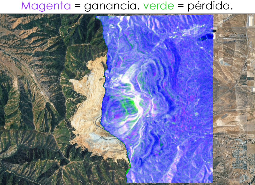
Análisis de cambios con SAR (Radar de Apertura Sintética) usando Sentinel-1 sobre la mina Bingham Canyon en Utah, donde ocurrió uno de los mayores deslizamientos de tierra de la historia minera el 10 de abril de 2013.
Category Archives: TERRAIN
From Overture Maps to GPKG in minutes: Building a Geospatial Data Extractor with R and DuckDB
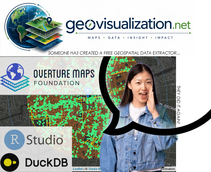
Modern geospatial workflows increasingly depend on fast, reliable access to city-scale vector data — building footprints, road networks, land use polygons, points of interest, address databases. Whether you are designing a 5G radio network, modelling urban heat islands, planning last-mile logistics, or simulating emergency response coverage, you almost always start from the same question: “How do I get clean, structured geodata for this city, right now, without spending two days on it?”
The Overture Maps Extractor is my answer to that question. It is a Shiny application written in R that lets any GIS professional extract multiple thematic layers from the Overture Maps Foundation dataset — for any city in the world — in a matter of minutes, with zero command-line interaction and zero manual data wrangling.
Setting up Mapterhorn terrain in RStudio
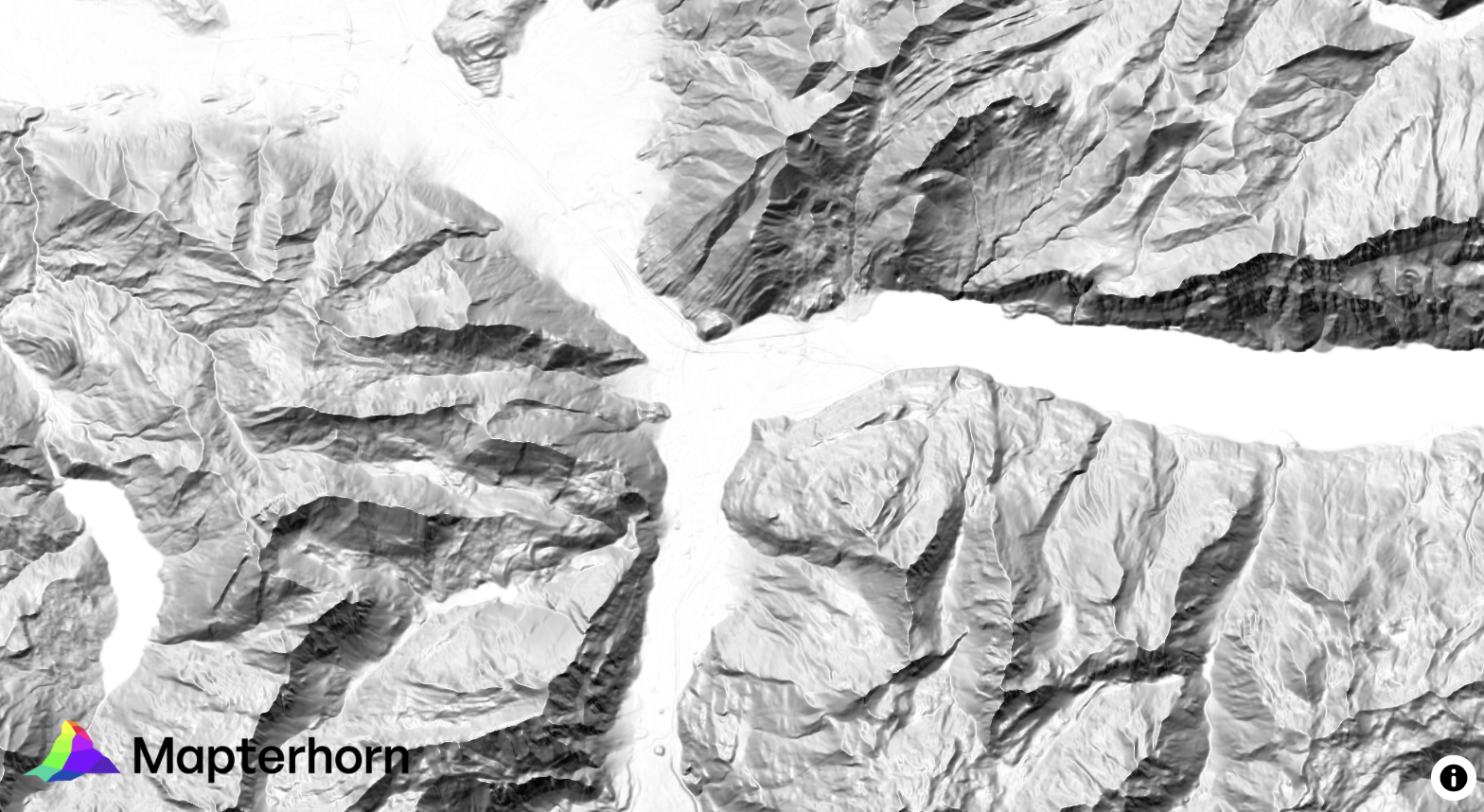
¿Alguna vez has querido visualizar el relieve de un territorio en 3D directamente desde R, sin depender de software GIS externo? Mapterhorn es un proyecto open source que distribuye modelos digitales de elevación (MDT) de alta resolución — hasta 2 metros en España — empaquetados en formato PMTiles, un estándar moderno que permite servir datos geoespaciales sin necesidad de un servidor propio.
En este post veremos cómo configurar Mapterhorn en R usando el paquete mapgl en Rstudio, que nos permite crear mapas interactivos con terreno 3D en pocas líneas de código. El resultado: visualizaciones como la que ves abajo, con sombreado de relieve (hillshade) generado directamente desde los datos de elevación del IGN.
From LIDAR USGS to DSM in a few lines of code. The magic of R
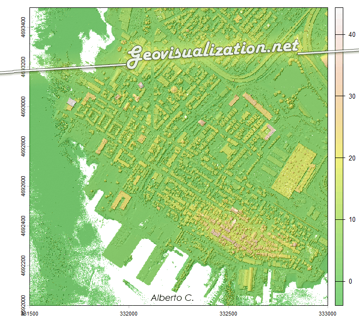
The USGS LiDAR Explorer, hosted via gishub.org, serves as a high-performance web gateway for interacting with the USGS 3D Elevation Program (3DEP) datasets. First thing, go to this GITHUB repository https://github.com/opengeos/maplibre-gl-usgs-lidar, download code for the project (code>download ZIP), get connected with RStudio, save new project and open a script window… It’s all set up!
Mapping Something Unthinkable: Flood Risk in Madrid using Open Data

Dont get wrong if you see the IA background showing our handsome major almost showing his beautiful smile in Cibeles/Correos it’s only to get your attentions (only if you need it thou!). Flooding in urban environments is not a speculative hazard but something we can quantify. In the case of Madrid, the intersection of pretty mountainous terrain (it might surprise you there are 2000m difference between the highest spot in Madrid province, Pico Peñalara -2428m- and the Alberche river environment in some areas -430m-) and urban expansion presents a scenario of significant risk, particularly when analyzed through the lens of shared high-resolution geospatial data. This study integrates the buildings from BTN (Base Topográfica Nacional) provided by the Spanish “IGN”, the CNIG with the official flood hazard maps for a 100-year return period (T=100), published by the Ministry for the Ecological Transition and the Demographic Challenge (MITECO). The T=100 scenario is the most representative for evaluating long-term flood exposure, as it reflects events with a 1% annual probability—rare but not improbable, and certainly not negligible.
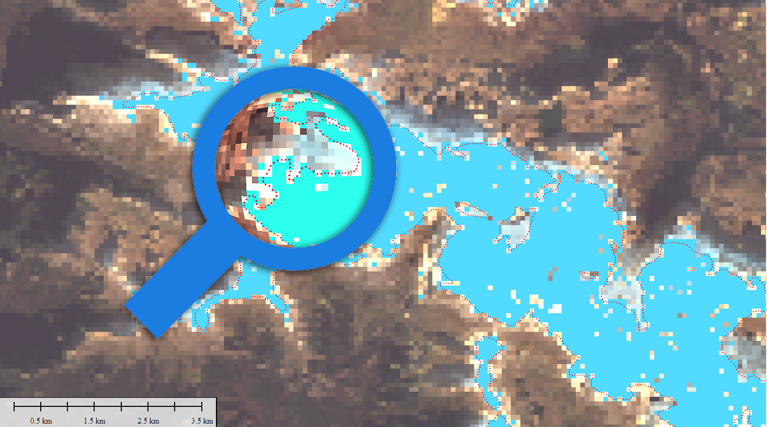
Sentinel-1 SAR: Un aliado indispensable para el análisis y seguimiento de inundaciones – Derna, Libia (2023)

La gestión y monitorización de fenómenos hidrológicos extremos, como inundaciones repentinas o fallos estructurales en presas, representan un desafío crítico para los especialistas en geomática, hidrología y planificación territorial. En este contexto, la tecnología radar de apertura sintética (SAR) a bordo del satélite Sentinel-1 de la Agencia Espacial Europea (ESA) ofrece una capacidad sin precedentes para capturar información precisa y fiable sobre la dinámica superficial, independientemente de las condiciones atmosféricas y lumínicas.
Mapping My 10-Year Adventure: Running Madrid to Ulaanbaatar 10,127 km

In August 2014, I laced up my running shoes for the first time, with no grand expectations — just a simple desire to move, to feel better, to take control. I was far from athletic: weighing nearly 80 kilograms (almost 20 kg more than today), with no endurance, no rhythm, and definitely no running background (exception made of some runs in my mid 20’s :-)). But I made myself a promise: I would be stubborn, consistent, and patient. No matter the weather — rain, wind, snow, scorching heat, storms — I would run, three times a week, every week.
The Remarkable Visibility of Almeria’s Greenhouses from Space

In the sphere of Earth observation and remote sensing, the Almeria greenhouses stand out as an astonishing spectacle visible even from the edge of space, defined by the Kármán line at approximately 100 kilometers in altitude. This unique visibility is not only a testament to the vast scale of human agricultural activity but also a captivating example of the power of satellite-based remote sensing technologies.
The beauty (and precision) of LIDAR:

Lidar, which stands for Light Detection and Ranging, is a technology that uses laser beams to measure distances and create detailed maps of the surrounding environment. It works by emitting laser pulses and then measuring the time it takes for the pulses to bounce back after hitting objects in their path. By analyzing the returning signals, lidar can accurately calculate the distance to various points and generate a three-dimensional map.
Measuring snow coverage using EOB – Earth Observation – Sentinel HUB
Playing with Sentinel 2 images I realized that the amount of snow this year has been very low compared to last winter. Here are a couple of images from January 2022 and 2023 of the Canfranc – Paticosa – Jaca area. One of the most interesting things about this EO browser is that in addition to a standard 2D visualisation, we can visualise in 3D. Here is an video example. Another interesting thing is to be able to quantify the snowfall. There is a snow classifier based on NSDI (Normalized Difference Snow Index, The Normalized Difference Snow Index (NDSI) snow cover is an index that is related to the presence of snow in a pixel and is a more accurate description of snow detection as compared to Fractional Snow Cover (FSC).
