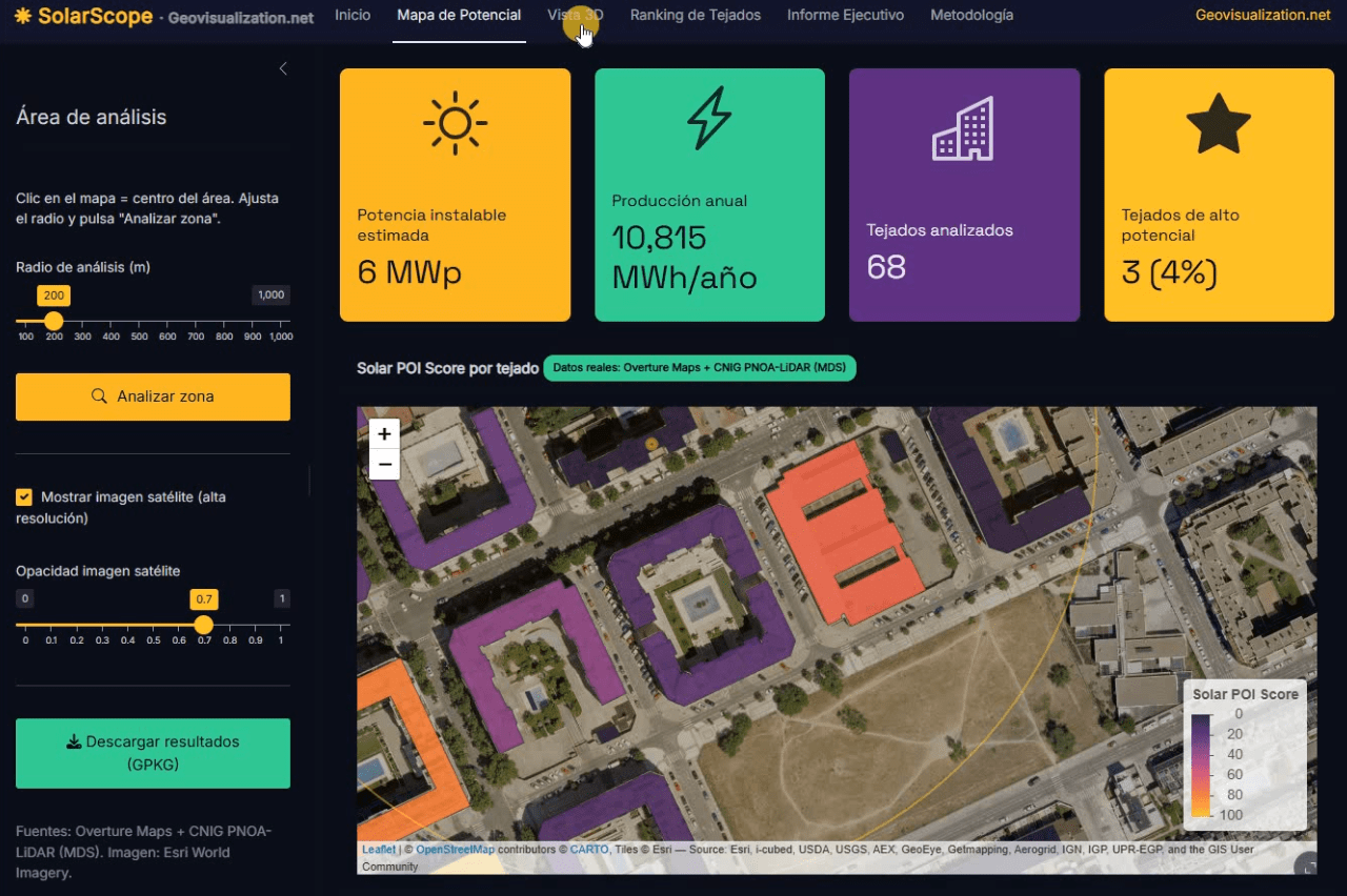
Llevo unos días dándole vueltas a una idea que, en el fondo, es bastante sencilla: si tenemos la huella de cada edificio, su altura y un modelo digital de superficies de alta resolución, ¿por qué seguimos viendo estudios de potencial solar que tratan los tejados como manchas homogéneas sobre un mapa? De esa pregunta, y de unas cuantas sesiones intensas de R, ha salido SolarScope, una aplicación Shiny que estoy desarrollando para hacer scoring de potencial fotovoltaico tejado a tejado, con datos abiertos y un flujo que se puede reproducir tanto en España como en Estados Unidos.
Category Archives: videos
AERIAL SURVEYOR SIMULATOR: Reimagining Aerial Photography
For three years, my office was thousands of feet in the air. As an aerial photographer, I spent my days capturing the world’s textures, layouts, and topographies from a cockpit—a masterclass in perspective that I am now transforming into a Aerial Surveyor Simulator.
From LIDAR USGS to DSM in a few lines of code. The magic of R
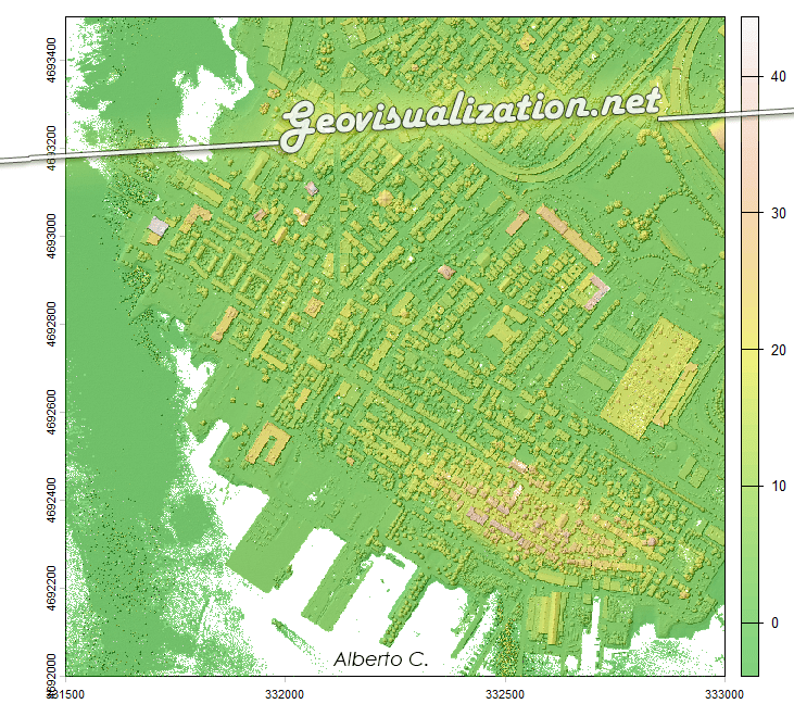
The USGS LiDAR Explorer, hosted via gishub.org, serves as a high-performance web gateway for interacting with the USGS 3D Elevation Program (3DEP) datasets. First thing, go to this GITHUB repository https://github.com/opengeos/maplibre-gl-usgs-lidar, download code for the project (code>download ZIP), get connected with RStudio, save new project and open a script window… It’s all set up!
Spatial relationship between “high schools” and “betting shops” in Madrid. A first approach (1)

It is a fact that a betting shop should not be close to a secondary school. Its obvious the impact on population ranging 12-17 could be higher than in other. How near? 100m? 500m? Euclidean distance or following the street network?. In any case, if I choose for instance a range of 500m, for example, 81% of betting shops in Madrid have secondary schools within that distance (258 out of 316). Looking at it from the secondary schools’ point of view, almost 60% of secondary schools have betting shops within 500m (171/291). This is undoubtedly an issue that needs to be addressed.
Water Quality Assessment based on Sentinel-2 Surface Reflectance over La Safor region, Valencia, Spain. Winter 2024-25

in light of meteorological conditions in the study area — specifically the occurrence of exceptionally heavy rainfall events in the La Safor region of Valencia — rooted in hydrological and sediment dynamics rather than in sensor or algorithmic artifacts.
Sequía en Cataluña – Timelapse 2017-2024

Las restricciones más duras de emergencia por sequía se extenderán a más de seis millones de personas de los 202 municipios de Barcelona y algunas poblaciones de Girona. Así lo ha anunciado este jueves la Generalitat, que suma estas localidades a las 37 (125.000 habitantes) de las comarcas de Alt Empordà, Baix Camp y Baix Llobregat, que ya estaban en la fase más severa desde agosto. Esto significa que casi el 80% de la población catalana vive en una zona en emergencia por la crisis hídrica.
No words (or almost)

Visualization 12-11-4 Sentinel 2 in relation to events in and around the Gaza Strip in early October 2023. It is difficult to remain aseptic even when talking about something technical. I will only say that I am ashamed of the world today. I am ashamed of the rulers and the ignorance of those who followContinue reading “No words (or almost)”
Digital Twin. Real-Time Public Transportation Visualization on LiveMaps360.com
The primary feature of LiveMaps360.com is its ability to display public transportation data in real-time. By integrating data from Tokyo’s extensive public transportation network, including buses, trains, and subways, the website enables users to track the movement of vehicles and access critical information such as arrival times, routes, and service disruptions.
The beauty (and precision) of LIDAR:

Lidar, which stands for Light Detection and Ranging, is a technology that uses laser beams to measure distances and create detailed maps of the surrounding environment. It works by emitting laser pulses and then measuring the time it takes for the pulses to bounce back after hitting objects in their path. By analyzing the returning signals, lidar can accurately calculate the distance to various points and generate a three-dimensional map.
Tracking fires LIVE: Boiro (A Coruña, Spain)

We can track this up as we speak. We can measure burn areas on a regular basis, creating videos, capture images, creating indexes, histograms, etc. Everything for better understanding what is going on and maybe, why not, avoiding it in te future. If you would like more information, dont hesitate to contact us.
