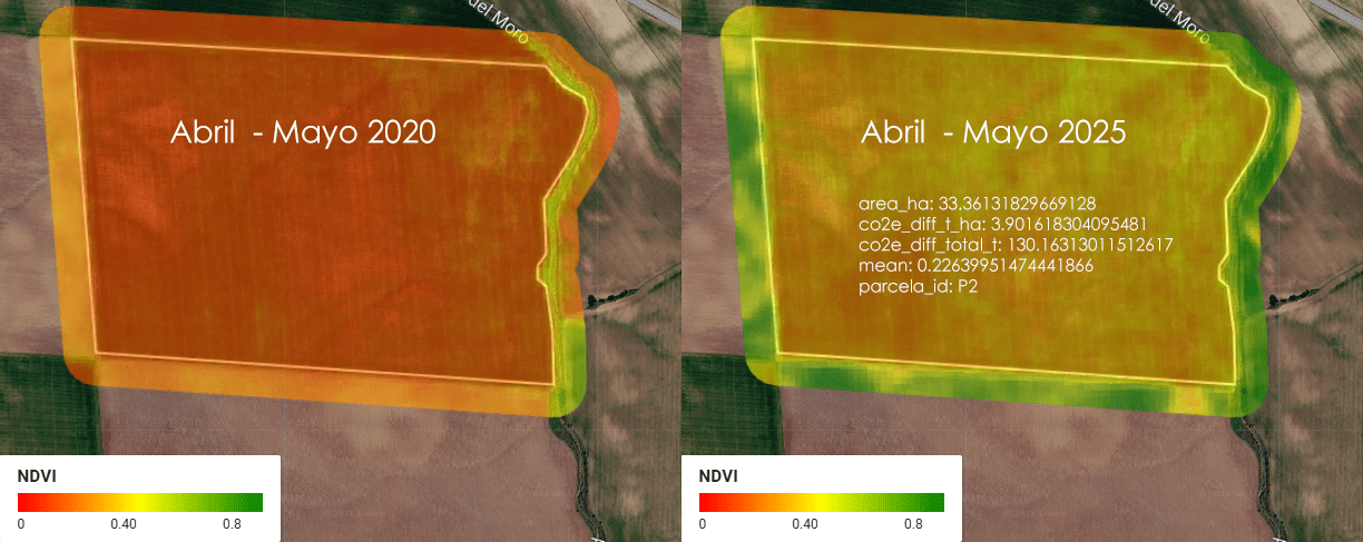
Imagina una empresa que se llama ACME. ACME es dueña de 5 parcelas de tierra en Almendralejo, Extremadura, España, donde se cultiva cereal (trigo, cebada, ese tipo de cosas). Entre las 5 parcelas, ACME tiene un total de 1.52 km² de tierra — para que te hagas una idea, eso es más o menos el tamaño de 300 campos de fútbol (a rzón de aproximadamente media hectárea por cada campo).
Category Archives: AI
KALMAN RADAR TRACKER: SEGUIMIENTO DE BLANCOS AÉREOS
Cuando alguien me pregunta sobre radar, pienso sobre todo en radares montados en satélites (sesgo geospacial) pero en realidad hay mucho más, hoy voy a hablaros de de radares aeroportados, de filtros de Kalman y seguimiento de blancos aéreos en movimiento… ¡Qué interesante!
Lo primero que pienso no es en el radar en sí, sino en el problema que resuelve, porque ese problema lo llevo resolviendo de otra forma desde hace años sin llamarlo por su nombre técnico. Un radar mide la posición de un avión con ruido. Un GPS mide la posición de un coche con ruido. Un sensor SAR mide el desplazamiento del terreno con ruido. En los tres casos hay una señal real escondida detrás de mediciones que saltan, que tiemblan, que nunca coinciden exactamente con la trayectoria verdadera. Y en los tres casos la respuesta es la misma matemática: combinar lo que predice el modelo físico con lo que dice el sensor, ponderando cada fuente según cuánto te fías de ella.
VENEZUELA EARTHQUAKE RESPONSE using DuckDB, Overture Maps and R
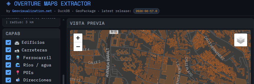
Just wanted to update on the usage of the tool I developed (OVERTURE MAPS EXTRACTOR) for extraction of Open data from Overture Maps for a quick hands on.
SolarScope: cuando el catastro, el LiDAR y el sol se sientan a la misma mesa
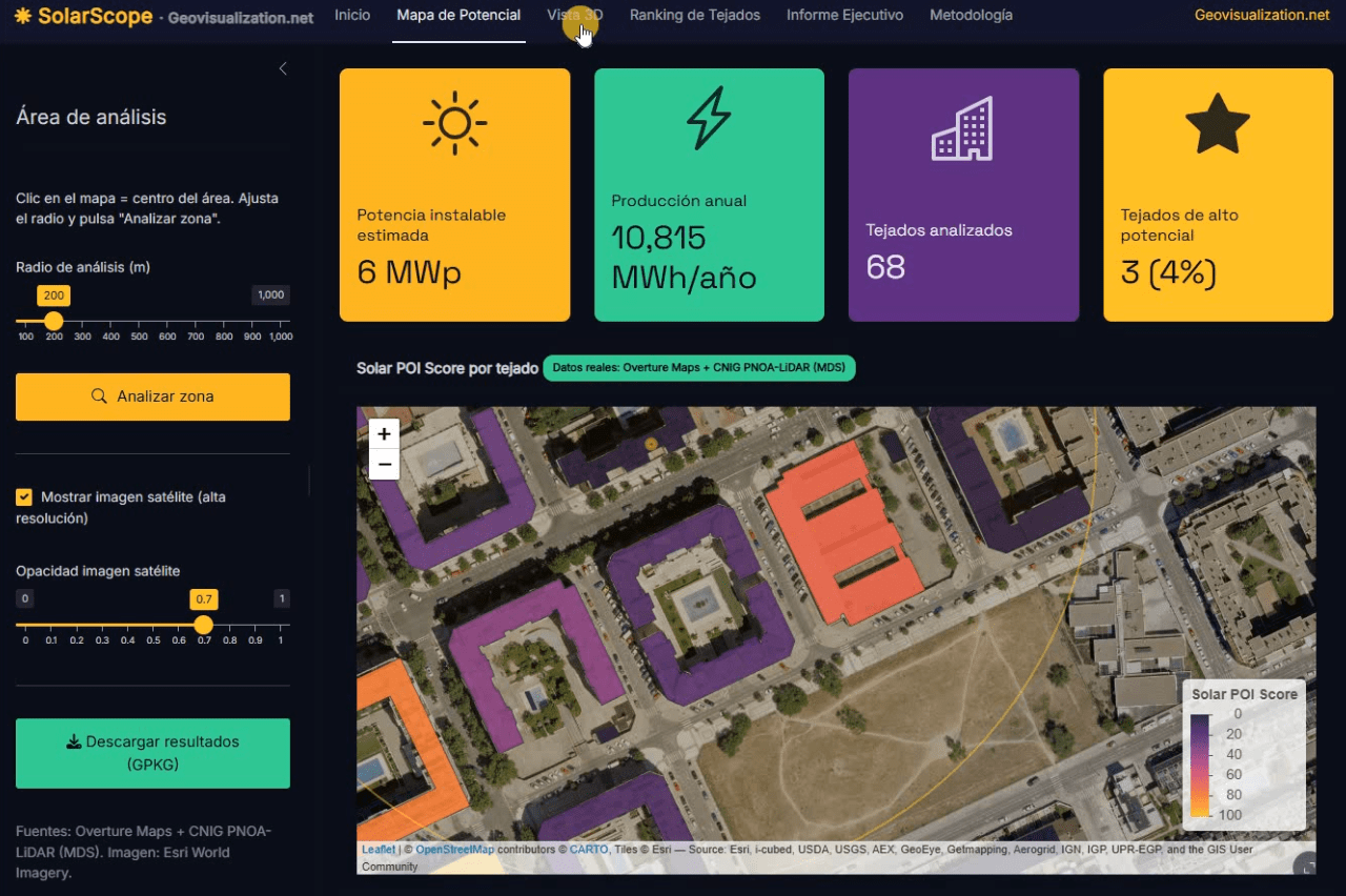
Llevo unos días dándole vueltas a una idea que, en el fondo, es bastante sencilla: si tenemos la huella de cada edificio, su altura y un modelo digital de superficies de alta resolución, ¿por qué seguimos viendo estudios de potencial solar que tratan los tejados como manchas homogéneas sobre un mapa? De esa pregunta, y de unas cuantas sesiones intensas de R, ha salido SolarScope, una aplicación Shiny que estoy desarrollando para hacer scoring de potencial fotovoltaico tejado a tejado, con datos abiertos y un flujo que se puede reproducir tanto en España como en Estados Unidos.
Time Series Analyzer: Análisis multitemporal de índices espectrales en Google Earth Engine
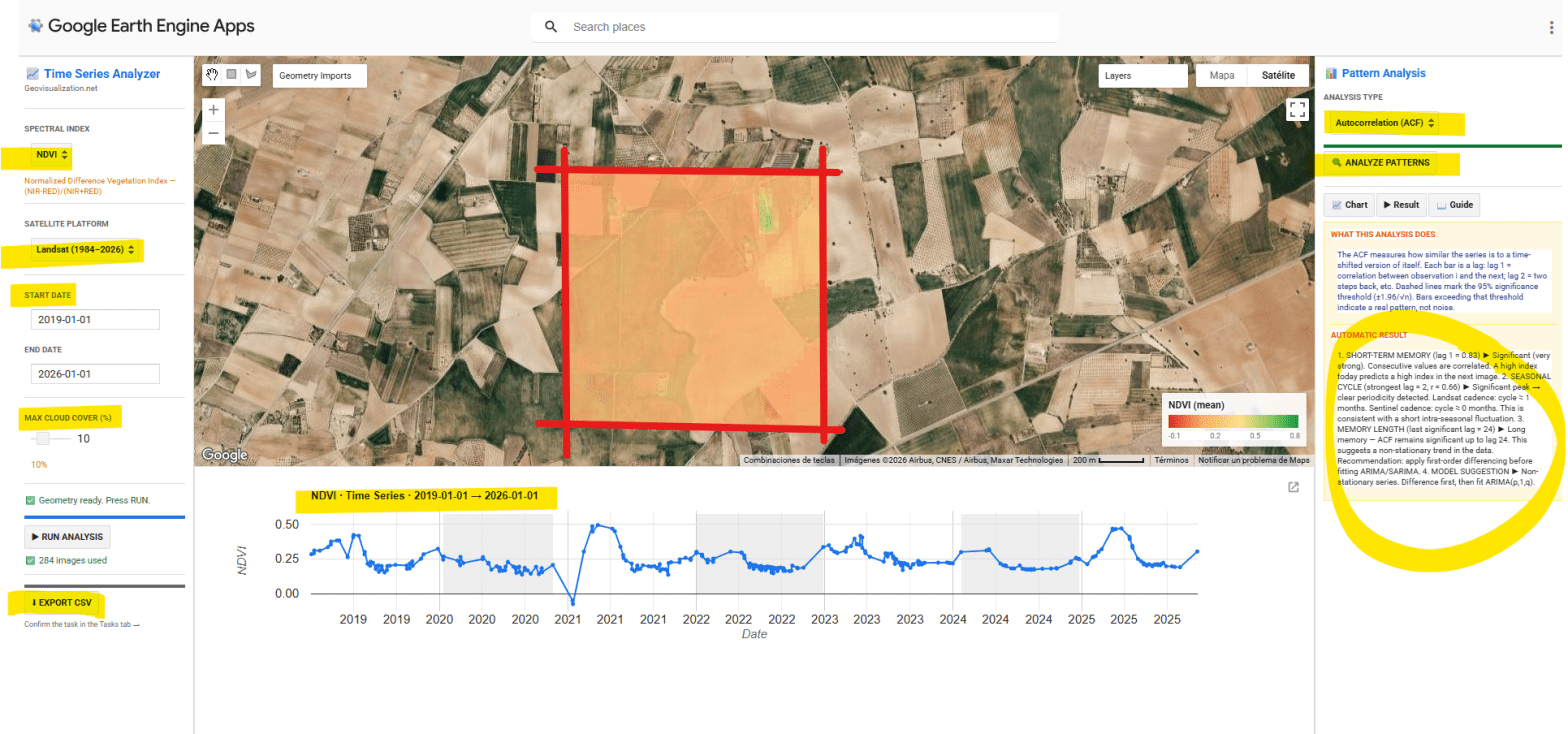
He desarrollado una aplicación interactiva en Google Earth Engine para la extracción y análisis estadístico automático de series temporales de cinco índices espectrales (NDVI, EVI, SAVI, NDWI y NBR) sobre cualquier geometría definida por el usuario en cualquier sitio del mundo. El objetivo es pasar de una imagen satélite puntual a una comprensión temporal del territorio: qué ha pasado, qué patrón subyace, y qué cabe esperar.
POI Intelligence for Urban Asset Analysis in RStudio: assetIQ
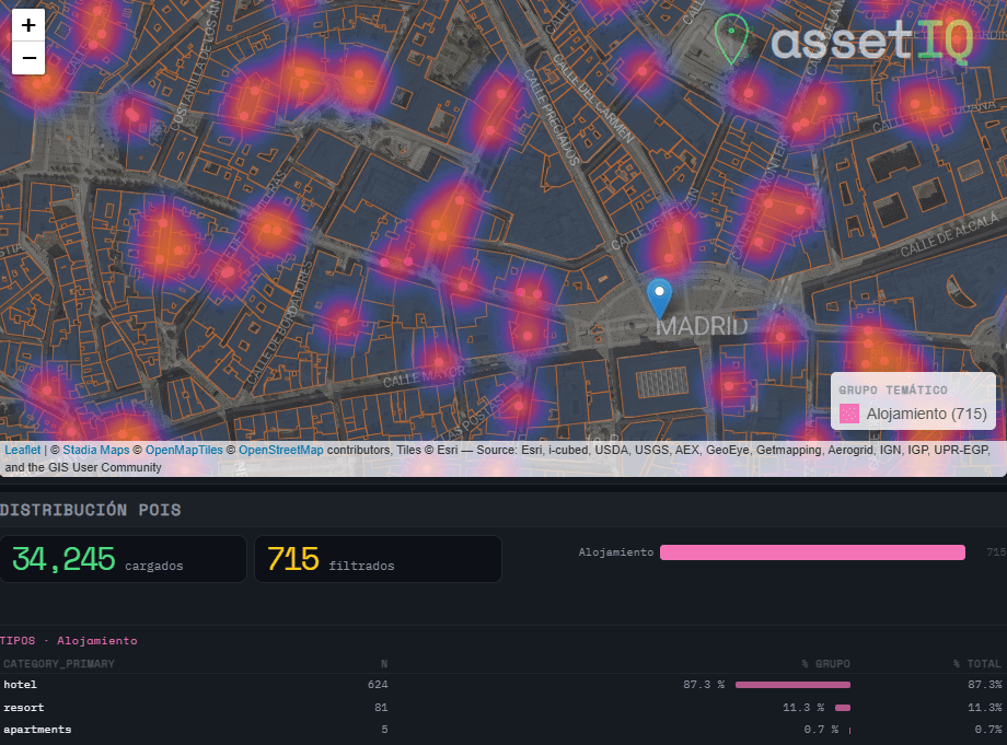
When analysing urban assets, there is genuine value in moving beyond generic neighborhood scores. The density of a coffee shop cluster, the proximity to a financial hub, or the concentration of accommodation around a transport node are signals that traditional datasets flatten into averages — or ignore entirely. assetIQ was built to change that. assetIQ is an R application powered by DuckDB and Overture Maps that extracts, classifies, and scores Points of Interest (POIs) for any location on Earth. You define a city and a search radius — from 100 meters to 25 kilometers — and the tool queries the Overture Maps Places dataset in real time, classifying each POI into thematic groups: Food & Drink, Retail, Health, Education, Transport, Accommodation, Financial Services, Leisure & Culture, Sport, and more.
The core output is an attribute value called POIQ: a normalized 0–1 score assigned to every building footprint within the area of interest, derived from a Kernel Density Estimation of the selected thematic group. A building in a dense retail corridor scores close to 1. An isolated residential block far from any commerce scores close to 0. This transforms thousands of individual points — which in raw form tell you very little — into a single, interpretable attribute per building, ready for downstream modelling, valuation, or site selection.
Mapterhorn + R: LOS analysis in seconds! 🚀

The analysis of LOS (Line of Sight) in telecommunications is the study that determines whether a clear, unobstructed path exists between a transmitting antenna and a receiver. While this calculation was traditionally reserved for large microwave links over long distances or in rural environments, the arrival of 5G networks and the horizon of 6G have turned it into an absolute priority for urban deployment, completely transforming how networks are planned in major cities.
SWEEPLY! HOME TASKS, SHARED

We’ve all been there. Domestic load is real, and tracking who does what at home can be a challenge—whether you want to balance tasks with your partner, get your kids to collaborate, or simply prove that chores don’t just “do themselves.”
