The primary feature of LiveMaps360.com is its ability to display public transportation data in real-time. By integrating data from Tokyo’s extensive public transportation network, including buses, trains, and subways, the website enables users to track the movement of vehicles and access critical information such as arrival times, routes, and service disruptions.
Tag Archives: arcgis
Running in Madrid. A GIS approach!

these density maps performed in Global Mapper overlay the geometry lines saved out my running application (Garmin Connect). and once they are exported to points, i can generate a density map, chosing an easy to understand legend and i overlay to Google Earth so its also easy to be sent if needed be (why for? i don’t know!).
Euclidean allocation analysis II

Imagine you need to promote recycling. Imagine you have 1000 inhabitants from a small village and you need to provide proper colored plastic bags for each and every one of the categories you need to disaggregate: organic, plastic and paper. You need to service them all properly but you can only choose 5 shops (out of theContinue reading “Euclidean allocation analysis II”
Allocation analysis: Attaching customers to facilities
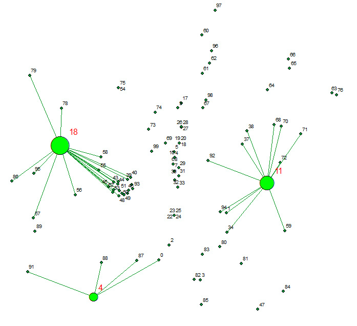
Allocates a set of demand points (Customers) to user specified number of supply points (Facilities) out of a Facilities point dataset based on the Euclidian distance between the Customers and Facilities.
Taxing the sun?. Yes, in Spain this seems to be possible.
Absolutely ashamed by my government’s insane policies on this regards, Spain is now (…) attempting to scale back the use of solar panels – the use of which they have encouraged and subsidized over the last decade – by imposing a tax on those who use the panels. The intention is clearly to scare taxpayersContinue reading “Taxing the sun?. Yes, in Spain this seems to be possible.”
Remote Sensing, Photogrammetry, Lidar and Landuse IGN Spain
A few more lines for leting you know again that i passed this other course just now in Instituto Geográfico of Spain (IGN). Remote Sensing, Photogrammetry, Lidar and Landuse, a comprehensive 40h update on relevant information i need tu use on a daily basis. This ‘update’ helps me to better understand what i am working with andContinue reading “Remote Sensing, Photogrammetry, Lidar and Landuse IGN Spain”
DTM from SRTM? Let’s compare sources using RMSE (Root Mean Square Error) and a gaussian kernell density map
I guess we all can make a DTM out of many sources but SRTM is one of the most common ones, right?. Then let’s learn from this very simple approach how close we are from the SRTM raw data. Selecting a not very big representative area to be able to handle it, exporting raster to polygon (fromContinue reading “DTM from SRTM? Let’s compare sources using RMSE (Root Mean Square Error) and a gaussian kernell density map”
Analyse du Localisation des équipements publics relevant du thème ‘Sports, loisirs’ de Nantes Métropole
La première chose a dire, comme toujours est: Désolé pour mon français, je fais mon mieux:-) Aujourd’hui je voudrais faire l’analyse sur la localisation des équipements publics de la thématique ‘Sports, loisirs’ de Nantes Métropole. http://data.paysdelaloire.fr/donnees/detail/localisation-des-equipements-publics-relevant-du-theme-sports-loisirs-de-nantes-metropole/ Les données donnent les coordonnées et la catégorie (centre sportif, circuit de plein air, stade, gymnase, espace sportif de proximité,Continue reading “Analyse du Localisation des équipements publics relevant du thème ‘Sports, loisirs’ de Nantes Métropole”
