
In the field of Earth observation and remote sensing, the Almeria greenhouses stand out as an astonishing spectacle visible even from the edge of space, defined by the Kármán line at approximately 100 kilometers in altitude. This unique visibility is not only a testament to the vast scale of human agricultural activity but also a captivating example of the power of satellite-based remote sensing technologies.

The network of greenhouses in Almeria, Spain, has become a distinctive feature observable from space. These structures, dedicated to horticulture, cover a vast expanse of land, creating a captivating mosaic that contrasts sharply with the surrounding terrain. The high reflectance of the greenhouse structures, combined with the contrasting colors of the vegetation within, makes them easily detectable by Earth observation satellites (like Sentinel-2) equipped with various sensors, including optical and infrared.

From a technical point of view, the visibility of Almeria’s greenhouses highlights the efficacy of satellite-based remote sensing in capturing fine details on Earth’s surface. Optical sensors, capable of discerning different wavelengths of light, enable the identification of specific features such as greenhouse structures and the types of crops being cultivated. Infrared sensors further enhance this capability by detecting variations in temperature and moisture content, providing valuable information about the health and vigor of vegetation and the surrounding areas.

The visibility of Almeria’s greenhouses from space is a captivating example of how human activities shape the landscape on a grand scale. It underscores the remarkable capabilities of remote sensing technologies, providing valuable insights into agricultural practices and environmental changes. As we continue to explore the frontiers of space-based observation, such phenomena serve as a reminder of the intricate interplay between technology, human activity, and the visual narrative of our planet as seen from above.
Beyond Almeria’s greenhouses, there are several other human-made artifacts that leave a discernible imprint on Earth when viewed from space. Urban areas with extensive artificial lighting, such as city lights at night, are prominent examples. The sprawling road networks and transportation infrastructure of major cities also contribute to their visibility. Large-scale industrial complexes, airports, and even certain types of deforestation leave distinctive marks that can be captured by satellite sensors.
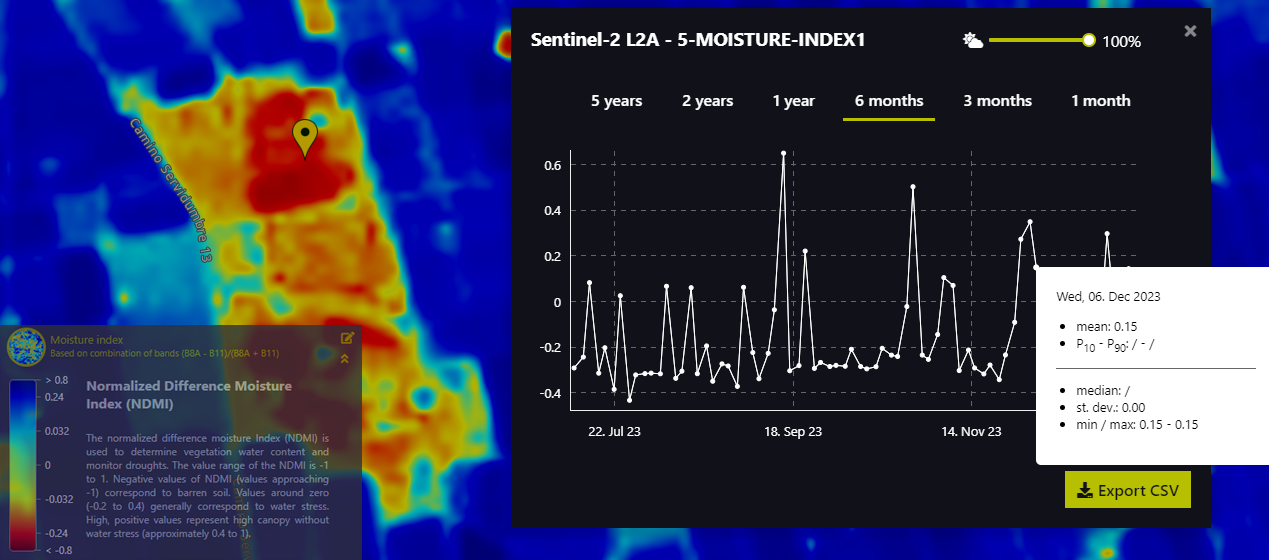
On the other side we can also link this visualization with Precision agriculture, which utilizes high-resolution satellite imagery (or drone’s) for remote sensing, enabling detailed monitoring of crop health and environmental conditions. Through the analysis of these images, farmers gain valuable insights into factors like soil moisture, nutrient levels, and pest infestations. This non-invasive approach facilitates precise decision-making, optimizing resource allocation and improving overall crop management. The use of high-resolution satellite imagery in precision agriculture promotes sustainable practices by minimizing input waste and maximizing agricultural productivity.
If you ever want to track moisture, nutrients, pests, create a landuse map or simply better understanding a variety of GIS related concepts over the spot or even creating an auto-descriptive time-lapse anywhere in the world, let me know!
Thanks!
Alberto C.
GIS analyst (and geo-phenomena enthusiast)
Sources:
https://apps.sentinel-hub.com/eo-browser
https://es.wikipedia.org/wiki/Objetos_visibles_desde_el_espacio
https://www.youtube.com/watch?v=N9IWrXQ_GoY&ab_channel=NOVAGRIC
