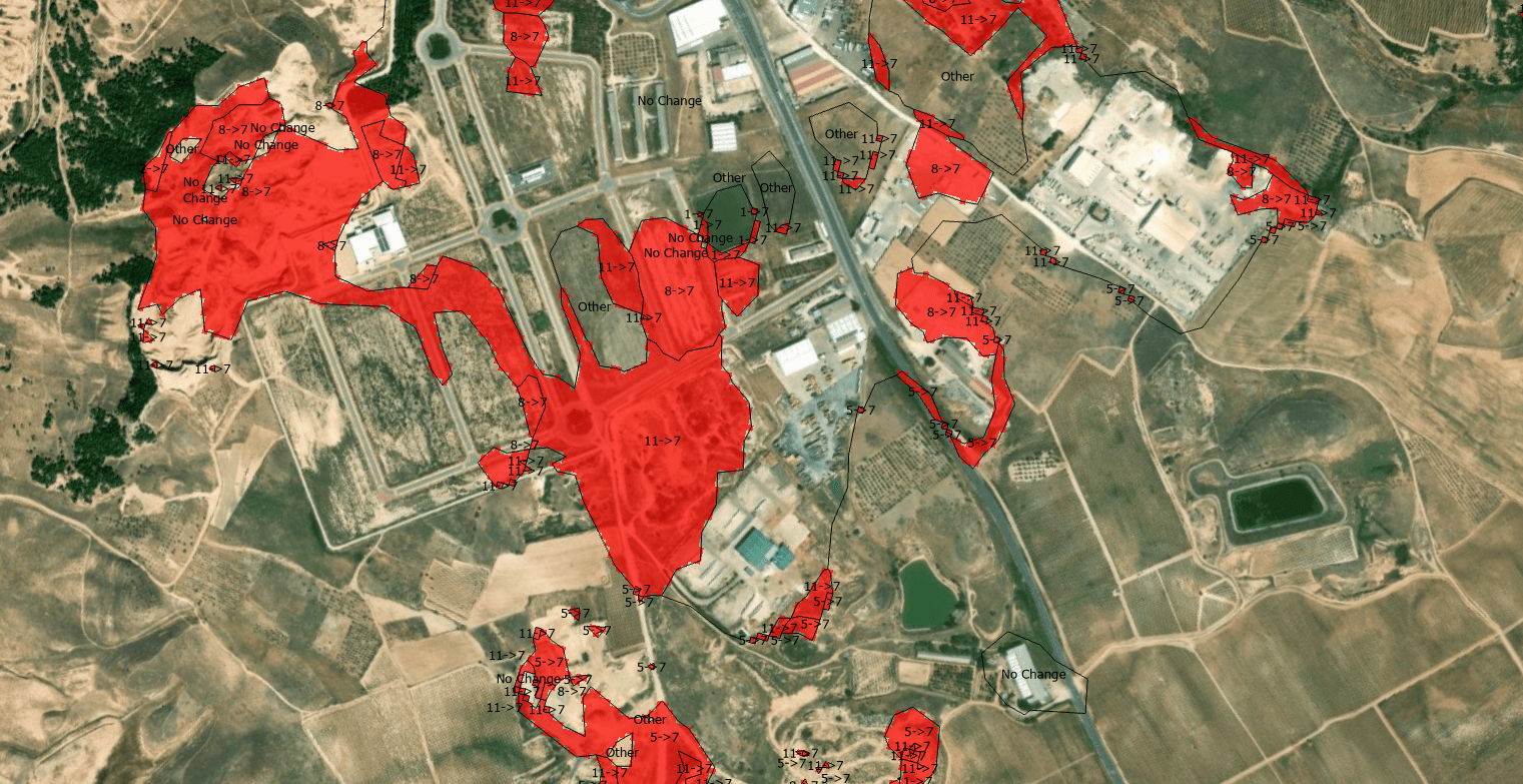
The quantification of land-use dynamics necessitates a spatiotemporal framework that ensures categorical stability over long-term observation windows. The ESRI 10-Meter Global Land Cover time series, accessible through the ArcGIS Living Atlas, provides a harmonized baseline for this purpose, derived from the dense temporal stack of the ESA Sentinel-2 mission.
Tag Archives: sentinel 2
Who Gets to See the War? Satellite Imagery Censorship and the Copernicus Alternative
A private company, operating under a US federal license, was effectively told by the Trump administration to go dark over an active war zone. Planet complied. Vantor and BlackSky — both heavily dependent on US defense revenue — said they hadn’t even received such a request, because they were already tightly controlling access. The selective pressure lands precisely on the most open, most commercially accessible provider. That is not a coincidence.A private company, operating under a US federal license, was effectively told by the Trump administration to go dark over an active war zone. Planet complied. Vantor and BlackSky — both heavily dependent on US defense revenue — said they hadn’t even received such a request, because they were already tightly controlling access. The selective pressure lands precisely on the most open, most commercially accessible provider. That is not a coincidence.
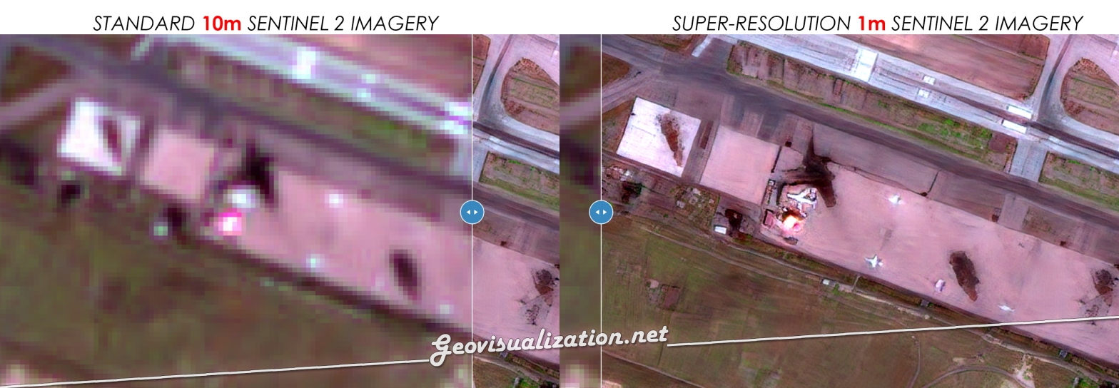
Super-résolution 1 m a Madrid avec Sentinel-2 10m. Magique ! Tracking NRT!
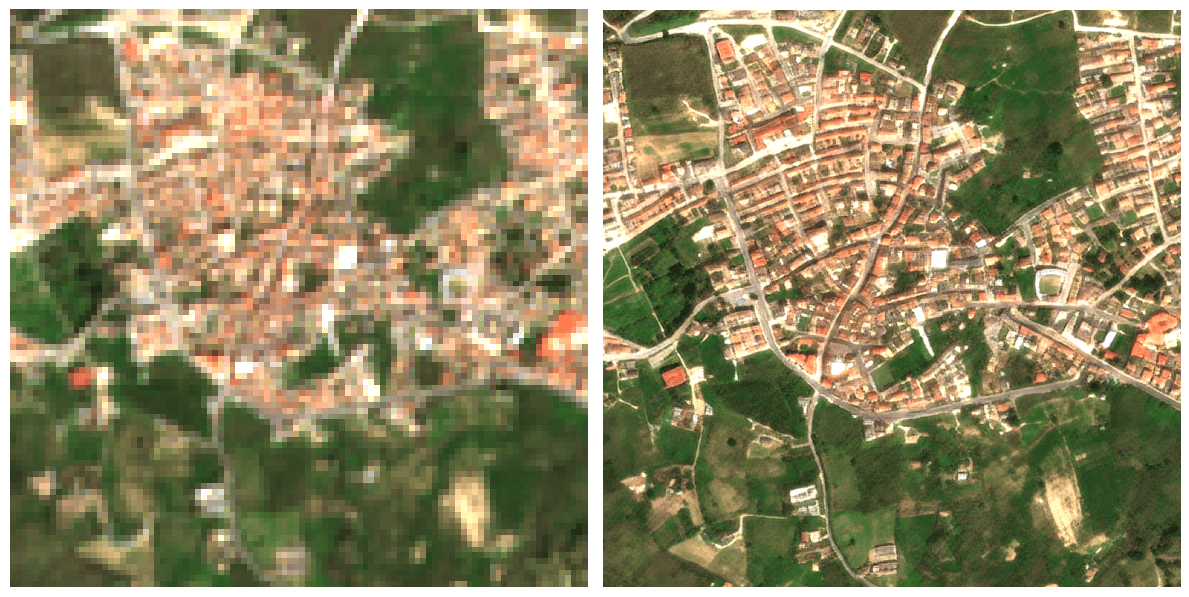
Passer d’une résolution de 10 mètres à 1 mètre change radicalement la perspective du suivi agricole : on ne regarde plus une parcelle dans sa globalité, on observe ce qui se passe à l’intérieur même des rangs de culture. Ce saut qualitatif est possible grâce à l’algorithme S2DR3, un modèle de Deep Learning qui ne se contente pas d’agrandir les pixels, mais reconstruit l’information manquante. En s’appuyant sur les corrélations entre les différentes bandes spectrales de Sentinel-2 et en s’entraînant sur des images de très haute résolution, l’IA parvient à synthétiser une image à 1 m/pixel d’une précision étonnante.
Wildfires in Russia through SENTINEL 2

In recent days, the Sakha region in Russia has experienced significant wildfire activity, More than 100 wildfires spanning more than 300,000 hectares are currently active. driven by a combination of extreme weather conditions and environmental factors. The fires, which have spread across vast areas of forest and tundra, have been exacerbated by unusually high temperatures and prolonged periods of drought. These conditions have led to exceptionally dry vegetation, creating an ideal fuel for the fires.
No words (or almost)

Visualization 12-11-4 Sentinel 2 in relation to events in and around the Gaza Strip in early October 2023. It is difficult to remain aseptic even when talking about something technical. I will only say that I am ashamed of the world today. I am ashamed of the rulers and the ignorance of those who followContinue reading “No words (or almost)”
Recuperación natural de un bosque de Pino Piñonero. Incendio en Pedro Bernado (Ávila)
En este micro vídeo he querido mostrar el proceso de recuperación natural de un bosque de Pino Piñonero (Pinus Pinea) a lo largo de tres años en Pedro Bernardo (Ávila, España). Fecha del incendio Junio 2019. Estimación previa a cuantificación: 40%. Imagenes Sentinel 2 – L2A. Usé una combinación 12-11-4. SWIR-2 (12), SWIR 1 (11), Red (4) entre las fechas de Junio 2019 y Junio 2022 a razón de una imagen al mes, seleccionando solo si ausencia total de nubes y cobertura total sobre la zona de análisis.
Wildfires in the sub-Saharan region

This image, acquired by one of the Copernicus Sentinel-2 on 8 February 2022, shows ongoing wildfires in the Boma National Park in South Sudan. Fires are common at this time of year in the sub-Saharan region.
