
This image, acquired by one of the Copernicus Sentinel-2 on 8 February 2022, shows ongoing wildfires in the Boma National Park in South Sudan. Fires are common at this time of year in the sub-Saharan region.


And a close up view below:
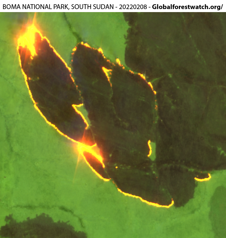


Most of them are linked to age-old agricultural practices aimed at clearing the land of brushwood and crop residues. According to the Global Forest Watch, more than 20,000 fire alerts have been issued in the area throughout the month of January, resulting in carbon emission levels in the atmosphere that are above the average, according to the Copernicus Atmosphere Monitoring Service (CAMS) data.
CAMS data are a global benchmark for monitoring harmful emissions in the atmosphere emitted by different sources (wildfires, volcanoes, etc).

Aquí la actualización Sentinel 2 – L2A del 8 de Febrero 2022. Combinación 12-11-4. SWIR-2 (12), SWIR 1 (11), Red (4).
https://www.staridasgeography.gr/how-to-make-outstanding-maps-with-sentinel-2-and-arcgis-pro-part-1-band-combinations/
Sources:
https://www.globalforestwatch.org,
https://apps.sentinel-hub.com/
https://www.instagram.com/copernicus_eu/
https://atmosphere.copernicus.eu/
https://pin.it/uGEDdhO
https://pin.it/69MRa0g
Own elaboration.

Impressive! we can even see a flair-like effect!