
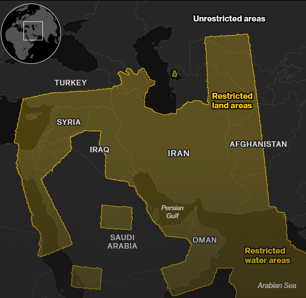
On April 5, 2026, Planet Labs announced it was complying with a US government request to indefinitely withhold high-resolution satellite imagery of a broad swathe of the Middle East — retroactively from March 9 — covering Iran, Iraq, Israel, Lebanon and the Persian Gulf States. The company moved to a “managed access” model, releasing images only on a case-by-case basis.
A private company, operating under a US federal license, was effectively told by the Trump administration to go dark over an active war zone. Planet complied. Vantor and BlackSky — both heavily dependent on US defense revenue — said they hadn’t even received such a request, because they were already tightly controlling access. The selective pressure lands precisely on the most open, most commercially accessible provider. That is not a coincidence.
This is not transparency. This is state-managed information blackout dressed up as voluntary cooperation.
The Asymmetry Is the Message
The US government did not ask all providers equally. It asked Planet — the one with the open-access model, the one serving journalists, researchers, NGOs, and ordinary citizens who want to understand what is happening in their name. Companies deeply embedded in the defense contracting ecosystem didn’t need asking. They were already compliant by design.
This asymmetry reveals the real intent: not security, but narrative control. When Bloomberg’s own analysis — using radar imagery from non-US sources — documents over 7,600 damaged or destroyed buildings in Iran including schools and health facilities, and the White House flatly denies it, you understand why high-resolution optical imagery had to disappear.
Enter Copernicus — and Why It Changes Everything
Here is what the US government apparently forgot, or hopes you don’t know: the European Union’s Copernicus programme is not under Washington’s jurisdiction (isn’t it?).
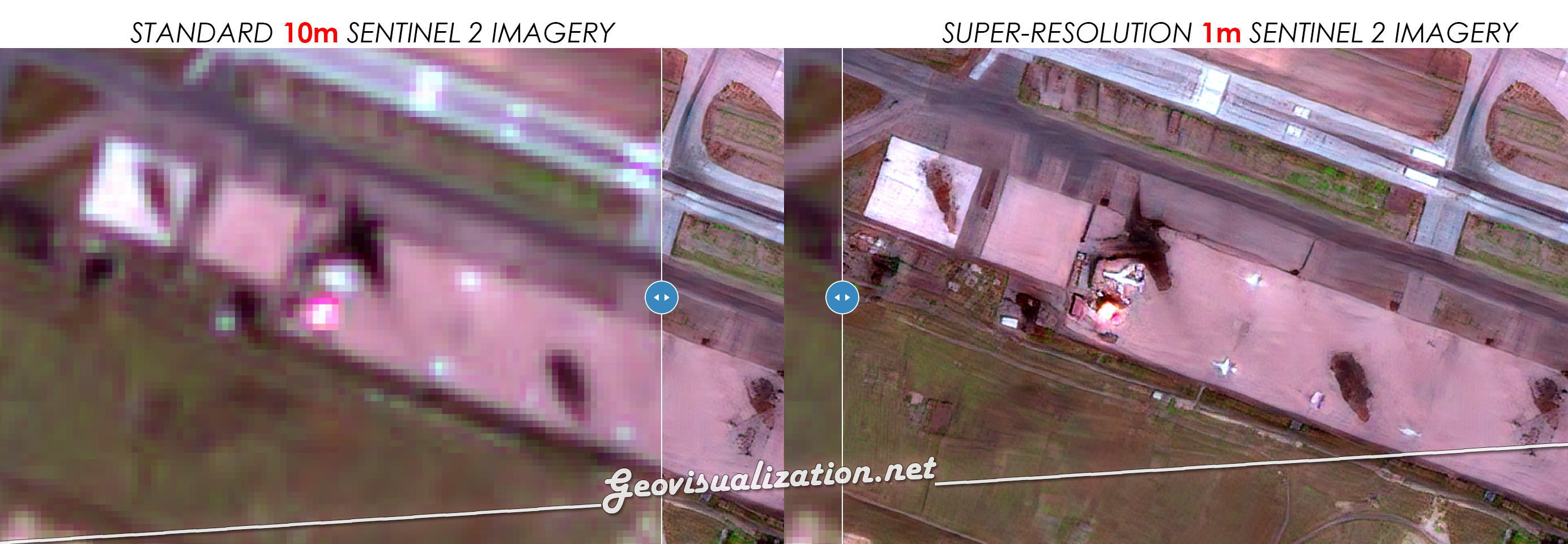
Sentinel-2 provides multispectral imagery at 10-metre resolution. More critically, the Sentinel-1 radar constellation captures the ground through clouds and at night — and it is precisely this data that researchers at Oregon State University used to map the destruction the US government tried to hide.
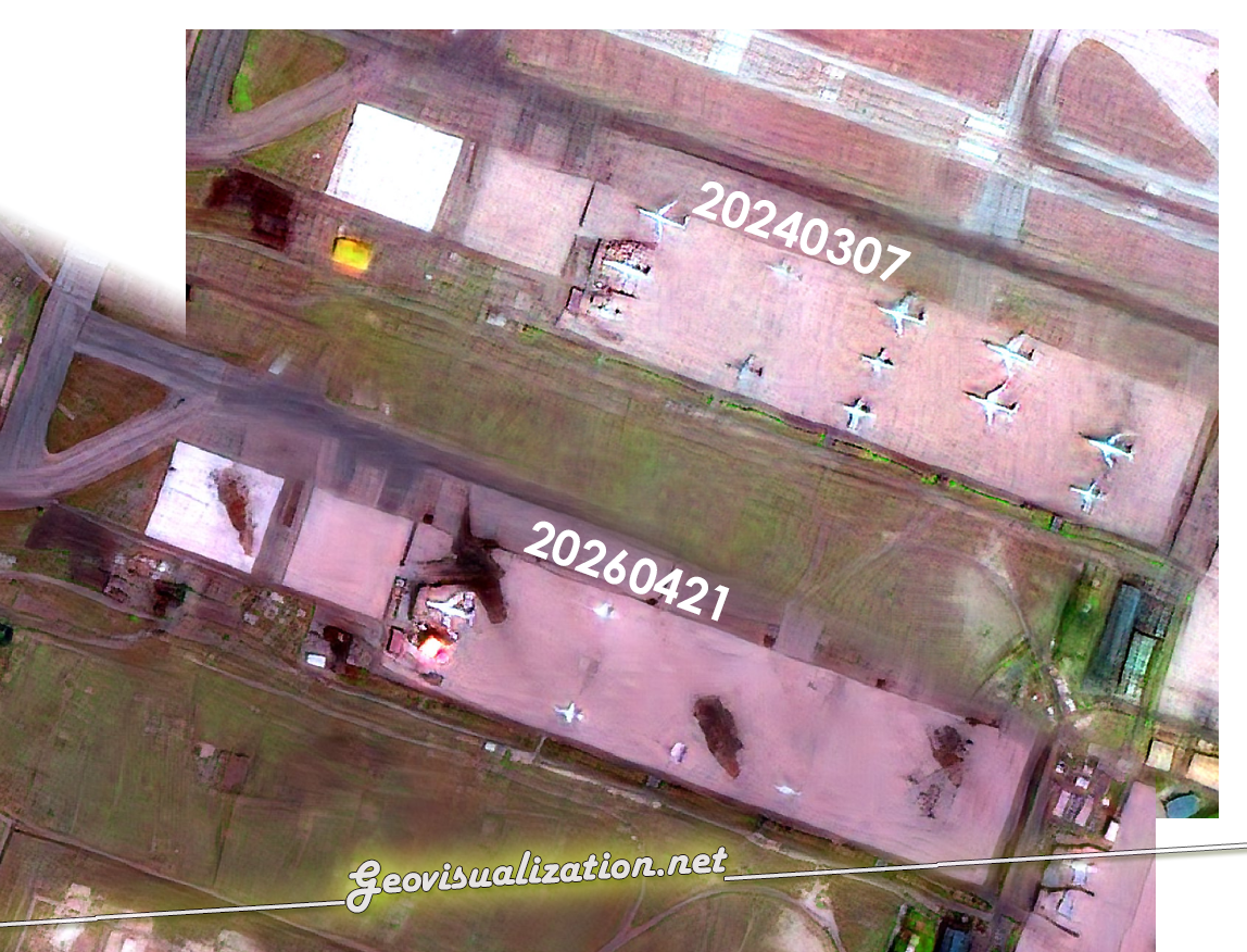
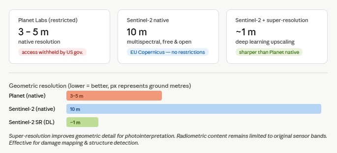
But the real game-changer is super-resolution. Applying deep learning models to Sentinel-2 data can produce outputs approaching 1-metre effective resolution — sharper than Planet’s native 3–5 m commercial imagery, and entirely outside the reach of any US export control or NOAA licensing mechanism. Copernicus data is free, open, and governed by the European Union, not by an administration that has a direct interest in what gets seen.
A Question of Democratic Accountability
The Copernicus programme was built on a principle: Earth observation is a public good. Citizens, scientists, journalists, and civil society deserve access to independent, verifiable information about what is happening on this planet — including when their governments are the ones doing it.
The United States is now openly demonstrating that it views commercial satellite operators as an extension of its information warfare capability. That should alarm everyone — not just geospatial professionals, but every citizen who believes that a functioning democracy requires an informed public.
The EU has a responsibility here. Copernicus must be defended, funded, and expanded — not as a scientific programme, but as a democratic infrastructure. And the open-source intelligence community, GIS professionals, researchers, and journalists have both the tools and the obligation to use it.
Alberto C.
Geospatial analyst
https://www.bloomberg.com/graphics/2026-satellite-imagery-restrictions-iran/
https://www.incibe.es/incibe-cert/blog/osint-la-informacion-es-poder
#Copernicus #RemoteSensing #OpenData #Sentinel #SuperResolution #EarthObservation #Transparency #OSIN
