The Ulyssys Water Quality Viewer harnesses the power of Sentinel-2 satellite data to provide comprehensive and accurate water quality assessments. Its intuitive legend and visualization capabilities significantly enhance the user’s ability to interpret and act on environmental data, contributing to better water management and conservation efforts worldwide, particularly in ecologically and economically significant areas like La Mata and Torrevieja salt lagoons.
Category Archives: statistique
The Remarkable Visibility of Almeria’s Greenhouses from Space

In the sphere of Earth observation and remote sensing, the Almeria greenhouses stand out as an astonishing spectacle visible even from the edge of space, defined by the Kármán line at approximately 100 kilometers in altitude. This unique visibility is not only a testament to the vast scale of human agricultural activity but also a captivating example of the power of satellite-based remote sensing technologies.
I FORO NACIONAL: CIENCIAS DE DATOS ESPACIALES COMO HERRAMIENTA EFICAZ EN LA GESTION PUBLICA. Lima (Perú)

Esta pasada semana he tenido el honor de viajar a Lima (Perú) para participar en el el Primer Foro Nacional de Ciencias de Datos Espaciales como herramienta eficaz para la gestión pública estos pasados 18-19 Julio 2023 en el Centro de Convenciones de Lima, Perú. Mi ponencia era sobre el DIGITAL TWIN en la ciudad de CUZCO así como el BRIGHT EARTH CITY TEXTURING, una solución de texturización procedural con semántica 3D de bajo mantenimento de mi empresa Luxcarta, un gran adelanto tecnológico de nuestro departamento de I+D.
Measuring snow coverage using EOB – Earth Observation – Sentinel HUB
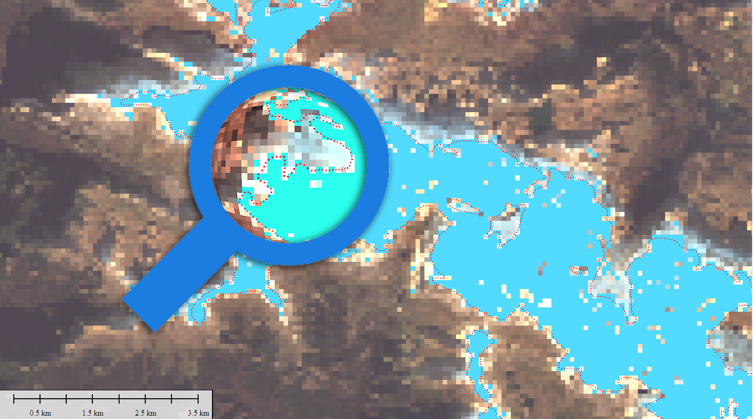
Playing with Sentinel 2 images I realized that the amount of snow this year has been very low compared to last winter. Here are a couple of images from January 2022 and 2023 of the Canfranc – Paticosa – Jaca area. One of the most interesting things about this EO browser is that in addition to a standard 2D visualisation, we can visualise in 3D. Here is an video example. Another interesting thing is to be able to quantify the snowfall. There is a snow classifier based on NSDI (Normalized Difference Snow Index, The Normalized Difference Snow Index (NDSI) snow cover is an index that is related to the presence of snow in a pixel and is a more accurate description of snow detection as compared to Fractional Snow Cover (FSC).
Consultoría e ideología: Manual de estupidez

Yo soy un humilde Geógrafo, además soy alguien curioso al que no le importa meterme en mil fregados por las razones más variadas, que ha trabajado y trabaja como tal pero también como diseñador, como fotógrafo o como comercial. He trabajado con obreros, con arquitectos, porteros de fincas, con dibujantes, con consultores de todos losContinue reading “Consultoría e ideología: Manual de estupidez”
Inland Water levels… Globally. Copernicus did it again!
The Water Observatory is an Earth-observation-based solution that provides reliable and timely information about surface water levels of waterbodies across the globe. All observations are provided and can be explored interactively via the Water Observatory Dashboard or via RESTful API. The Water Observatory provides a valuable service to local authorities, governmental agencies, natural parks and reserves, agricultural ministries and agencies, stakeholders in food and energy production, and citizens alike.
Google Earth Engine and Dynamic World

Let me please introduce you this “new” LULC source I have come across with recently. The potential of this 10m “clutter” source is being able to acquire data from a few days ago instead of using outdated “very old” 2020 vintage datasets. I know if these days something 2020 is very old then myself, born in 1972 then i’m older than the riverside, older than peeing in a wall, even older than Methuselah. Yes, that’s the way it is nowadays.
Google Earth Engine is a geospatial processing service where you can perform geospatial processing at scale, powered by Google Cloud Platform. The purpose of Earth Engine is to:
Provide an interactive platform for geospatial algorithm development at scale
Enable high-impact, data-driven science
Make substantive progress on global challenges that involve large geospatial datasets
Tracking fires LIVE: Boiro (A Coruña, Spain)

We can track this up as we speak. We can measure burn areas on a regular basis, creating videos, capture images, creating indexes, histograms, etc. Everything for better understanding what is going on and maybe, why not, avoiding it in te future. If you would like more information, dont hesitate to contact us.
Recuperación natural de un bosque de Pino Piñonero. Incendio en Pedro Bernado (Ávila)
En este micro vídeo he querido mostrar el proceso de recuperación natural de un bosque de Pino Piñonero (Pinus Pinea) a lo largo de tres años en Pedro Bernardo (Ávila, España). Fecha del incendio Junio 2019. Estimación previa a cuantificación: 40%. Imagenes Sentinel 2 – L2A. Usé una combinación 12-11-4. SWIR-2 (12), SWIR 1 (11), Red (4) entre las fechas de Junio 2019 y Junio 2022 a razón de una imagen al mes, seleccionando solo si ausencia total de nubes y cobertura total sobre la zona de análisis.
Marathon à Nantes 2022: CHECKED!

J’ai toujours cru que faire les choses selon un plan facilitait la réalisation de ce que vous aviez prévu de faire, eh bien, quand il s’agit de courir un Marathon, c’est la clé. Lors de mon troisième Marathon après Valencia en 2017 et Madrid en 2019, on constate une meilleure tendance par rapport au nombre de kilomètres de préparation.
