The BlueDot Water Observatory provides timely information about water levels of lakes, dams, reservoirs, wetlands and similar water bodies globally. It is based on the Copernicus satellite imagery, acquired using sentinelhub Python package, which uses Sentinel Hub services.
The key benefit of the service is the accumulation of global current and historical water level data in one place. Due to its cost-effective approach, anyone is able to access water level information freely; not only authorities, but also citizens can now better understand the state of their local and global environment.

With over three quarters of water covering the planet and 70% of human body consisting of water, this wonder liquid permeates both land and body, making it an essential substance both for the development and nourishment of life and the sustenance of the environment. For human needs—apart from our dependence on it for survival—water also lies at the heart of economic and social development. In times of abundance, water enables economic growth, which in turn reduces poverty, and in times of scarcity, it can cause life-threatening crises. To be able to predict such disasters, water monitoring is of utmost importance.
The Water Observatory is an Earth-observation-based solution that provides reliable and timely information about surface water levels of waterbodies across the globe. All observations are provided and can be explored interactively via the Water Observatory Dashboard or via RESTful API. The Water Observatory provides a valuable service to local authorities, governmental agencies, natural parks and reserves, agricultural ministries and agencies, stakeholders in food and energy production, and citizens alike.
The global database of water bodies – lakes, dams, reservoirs – is built on top of existing databases:
- Global Reservoir and Dam (GRanDv1.01) database,
- WWF’s Global Lakes and Wetlands Database (levels 1 and 2).
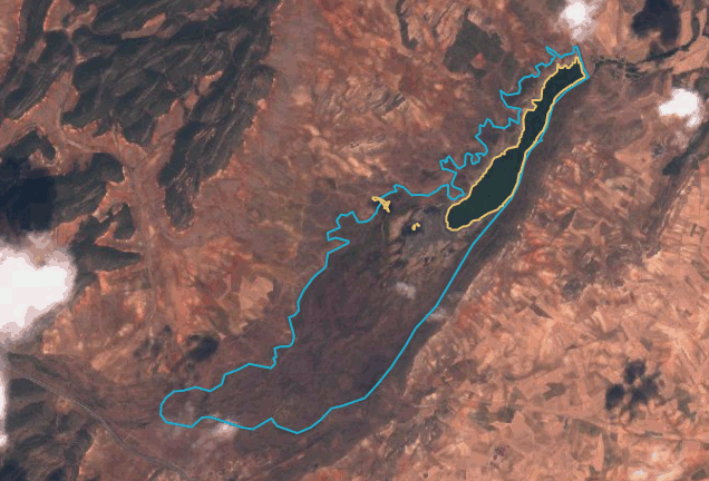
Unfortunately, the accuracy of polygons outlining the nominal extent of the water bodies in these databases is insufficient (see Figures below). We therefore used these datasets as collection of potentially interesting water bodies and extracted their polygons from the OpenStreetMap. The database is available here.
At the moment, our database consists of over 40000 waterbodies, out of which around 7000 are monitored and displayed in the Water Observatory Dashboard.

The Water Observatory extracts the surface water levels from Sentinel-2 optical satellite imagery provided by the Copernicus program. The algorithm is implemented in Python and among other consists of the following steps:
- download single-band image of a Normalized Difference Water Index (NDWI) using Sentinel Hub‘s WCS service
- detect clouds using Sinergise’s s2cloudless cloud detector
- reject all images that are too cloudy
- run Canny edge detector on the NDWI single-band image and dilate the edges
- derive binary water mask with Otsu’s method using only the dilated-edge-pixels
- polygonize water mask with rasterio
The Water Observatory results can be explored using its dashboard. Simply navigate the map (pan and zoom) [3] to select a waterbody (dots in the map). After the waterbody is selected all other elements in the dashboard get updated:
- Search console, name of the waterbody and country, date of observation, water coverage and total number of all valid observations for selected waterbody.
- True color image of selected waterbody with nominal water extent and observed water extent.
- Surface water levels since end of the 2015 up to the most recent Sentinel-2 image from few days ago. Selection of an observation on another date updates the image.
This is the way the dashboard works. Almost magic.

And this other GIF playing inversely (amazing how this minor visualization change helps us to understand what is going on very quickly, also how important using up-to-date vectors is).
Sources:
https://water.blue-dot-observatory.com/20019/2019-12-03
https://www.blue-dot-observatory.com/aboutwaterobservatory
https://medium.com/sentinel-hub/bluedot-eo-solution-for-water-resources-monitoring-d7663c21af16
https://medium.com/sentinel-hub/global-earth-observation-service-from-your-laptop-23157680cf5e
https://github.com/sentinel-hub/water-observatory-backend
Software used:
GIMP
Autoclicker
Auto Screen Capture
Hope you like this,
Alberto
GIS Analyst
