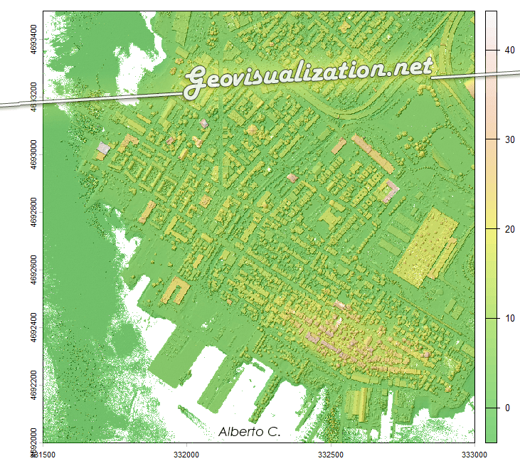
The USGS LiDAR Explorer, hosted via gishub.org, serves as a high-performance web gateway for interacting with the USGS 3D Elevation Program (3DEP) datasets. First thing, go to this GITHUB repository https://github.com/opengeos/maplibre-gl-usgs-lidar, download code for the project (code>download ZIP), get connected with RStudio, save new project and open a script window… It’s all set up!
Tag Archives: Global Mapper
Mapping Something Unthinkable: Flood Risk in Madrid using Open Data

Dont get wrong if you see the IA background showing our handsome major almost showing his beautiful smile in Cibeles/Correos it’s only to get your attentions (only if you need it thou!). Flooding in urban environments is not a speculative hazard but something we can quantify. In the case of Madrid, the intersection of pretty mountainous terrain (it might surprise you there are 2000m difference between the highest spot in Madrid province, Pico Peñalara -2428m- and the Alberche river environment in some areas -430m-) and urban expansion presents a scenario of significant risk, particularly when analyzed through the lens of shared high-resolution geospatial data. This study integrates the buildings from BTN (Base Topográfica Nacional) provided by the Spanish “IGN”, the CNIG with the official flood hazard maps for a 100-year return period (T=100), published by the Ministry for the Ecological Transition and the Demographic Challenge (MITECO). The T=100 scenario is the most representative for evaluating long-term flood exposure, as it reflects events with a 1% annual probability—rare but not improbable, and certainly not negligible.
Urban Heat Islands, Trees, and Climate Justice in the Anthropocene: A Remote Sensing-Based Reflection

In recent years, the need to understand the urban environment has grown more urgent than ever. Climate change is not an abstract future scenario; it is already here, reshaping our cities day by day. Among the many phenomena that demand our attention, the Urban Heat Island (UHI) effect stands out—not only for its environmental and public health impacts but also for its socio-political implications. Through satellite imagery and remote sensing, we can now visualize and quantify these dynamics with increasing precision. This post reflects on such an analysis I conducted using LANDSAT 8 imagery (Scene ID: LC08_L2SP_201032_20250328_20250401_02_T1, Date Acquired: 2025/03/28), and discusses the findings in the broader context of urban planning, climate justice, and the urgent need to protect urban vegetation.
UPDATED TODAY! Enfoque “Open data” para la toma de decisiones en tiempos de Coronavirus COVID-19

Decenas de medios y redes sociales, algunos poco fiables por incapaces o partidistas (o las dos cosas), muchos datos, no necesariamente bien extraídos y analizados, varios criterios no harmonizados y cambiantes (en los últimos días dos veces han cambiado los criterios del Ministerio de Sanidad español!) me convencieron para hacer los análisis yo mismo pero esto, claro, requiere un poco de tí. Los periodistas no tienen por qué tener nociones de estadística o de análisis espacial pero yo sí. Tengo acceso a OPEN DATA (Datos Abiertos) y ganas de análisis? Vamos a ver qué sale de esto.
Running in Madrid. A GIS approach!

these density maps performed in Global Mapper overlay the geometry lines saved out my running application (Garmin Connect). and once they are exported to points, i can generate a density map, chosing an easy to understand legend and i overlay to Google Earth so its also easy to be sent if needed be (why for? i don’t know!).
Running en Nantes

Cada vez que corría por esta maravillosa ciudad, lo grababa con la aplicación Runkeeper, así que he superpuesto todas las ocasiones para ver dónde exactamente se concentran las rutas que más he usado y las zonas por las que he pasado más veces. Esto es lo mal de concentrar en la misma persona alguien alContinue reading “Running en Nantes”
Réalisation du carte de densité pour vérifier Localisation des colonnes aériennes de Nantes Métropole

Localisation et caractéristiques des colonnes d’apport volontaire aériennes de Nantes Métropole utilisées pour la collecte des déchets. Outil de visualisation Global Mapper 17 Format SHP champ: VOLUME http://data.paysdelaloire.fr/donnees/detail/localisation-des-colonnes-aeriennes-de-nantes-metropole/ Ces colonnes sont implantées sur l’ensemble du territoire et sont destinées à la collecte du verre et des emballages recyclables (papier, carton, plastique). C’est genial jouer unContinue reading “Réalisation du carte de densité pour vérifier Localisation des colonnes aériennes de Nantes Métropole”
DTM from SRTM? Let’s compare sources using RMSE (Root Mean Square Error) and a gaussian kernell density map
I guess we all can make a DTM out of many sources but SRTM is one of the most common ones, right?. Then let’s learn from this very simple approach how close we are from the SRTM raw data. Selecting a not very big representative area to be able to handle it, exporting raster to polygon (fromContinue reading “DTM from SRTM? Let’s compare sources using RMSE (Root Mean Square Error) and a gaussian kernell density map”
Cool data. What is this?
What is this ‘cool data‘ all about?. When i got my degree in Geography (about 15 years ago) it didn’t make sense at all being interested in something like graphic design, photography, video and all this stuff… but not only interested in my leisure time but also for taking advantage of it, getting a lifeContinue reading “Cool data. What is this?”
Data acquisition: How do I know if this river is been well acquired?
I’ve already entered my river but my imagery was in 2D so… was it well acquired?… First of all, I import my shape (shp) file into Global Mapper (what a great sofware!) and export my vector file as a KML. Import my river.kml file into my brand new Google Earth 5.2 or just double-click itContinue reading “Data acquisition: How do I know if this river is been well acquired?”
