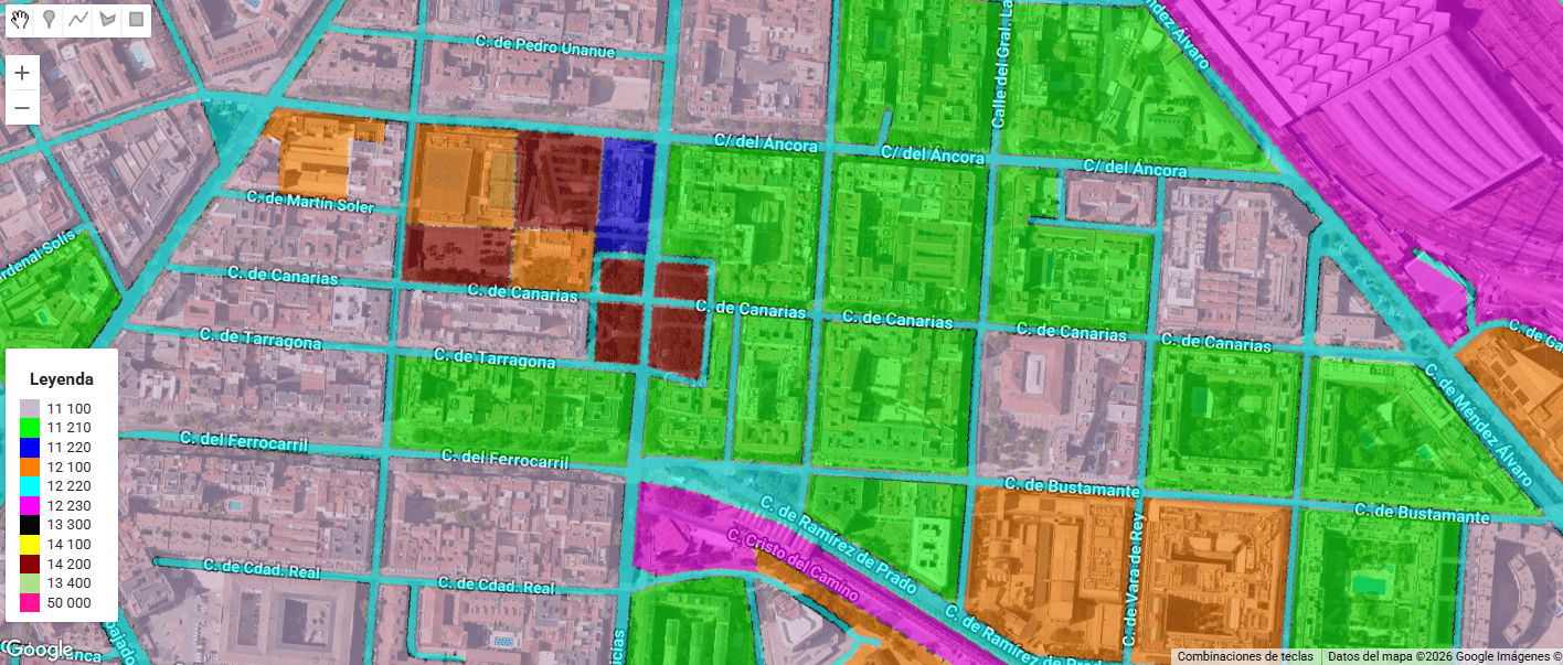
Urban Atlas (UA) representa el estándar de oro dentro del Copernicus Land Monitoring Service (CLMS) para el análisis de la morfología urbana en Europa. A diferencia de Corine Land Cover, UA ofrece una resolución temática y espacial drásticamente superior (Unidad Mínima de Mapeo de 0.25 ha para clases urbanas), permitiendo discriminar entre tejidos urbanos continuos y discontinuos con una precisión de densidad del 10% al 80%.
Tag Archives: copernicus
¡Al final se nos quema la península este 2025!

Este agosto, España y Portugal han vivido una temporada de incendios excepcionalmente dura. En España, las llamas han calcinado ~382.000 hectáreas (más de seis veces la media reciente) y han dejado víctimas mortales; en Portugal, las superficies quemadas superan las 200.000 hectáreas, muy por encima del promedio 2006–2024 para estas fechas. El humo cruzó fronteras y degradó la calidad del aire a cientos de kilómetros.
Water Quality Assessment based on Sentinel-2 Surface Reflectance over La Safor region, Valencia, Spain. Winter 2024-25

in light of meteorological conditions in the study area — specifically the occurrence of exceptionally heavy rainfall events in the La Safor region of Valencia — rooted in hydrological and sediment dynamics rather than in sensor or algorithmic artifacts.
Wildfires in Russia through SENTINEL 2

In recent days, the Sakha region in Russia has experienced significant wildfire activity, More than 100 wildfires spanning more than 300,000 hectares are currently active. driven by a combination of extreme weather conditions and environmental factors. The fires, which have spread across vast areas of forest and tundra, have been exacerbated by unusually high temperatures and prolonged periods of drought. These conditions have led to exceptionally dry vegetation, creating an ideal fuel for the fires.
No words (or almost)

Visualization 12-11-4 Sentinel 2 in relation to events in and around the Gaza Strip in early October 2023. It is difficult to remain aseptic even when talking about something technical. I will only say that I am ashamed of the world today. I am ashamed of the rulers and the ignorance of those who followContinue reading “No words (or almost)”
Measuring snow coverage using EOB – Earth Observation – Sentinel HUB
Playing with Sentinel 2 images I realized that the amount of snow this year has been very low compared to last winter. Here are a couple of images from January 2022 and 2023 of the Canfranc – Paticosa – Jaca area. One of the most interesting things about this EO browser is that in addition to a standard 2D visualisation, we can visualise in 3D. Here is an video example. Another interesting thing is to be able to quantify the snowfall. There is a snow classifier based on NSDI (Normalized Difference Snow Index, The Normalized Difference Snow Index (NDSI) snow cover is an index that is related to the presence of snow in a pixel and is a more accurate description of snow detection as compared to Fractional Snow Cover (FSC).
Inland Water levels… Globally. Copernicus did it again!
The Water Observatory is an Earth-observation-based solution that provides reliable and timely information about surface water levels of waterbodies across the globe. All observations are provided and can be explored interactively via the Water Observatory Dashboard or via RESTful API. The Water Observatory provides a valuable service to local authorities, governmental agencies, natural parks and reserves, agricultural ministries and agencies, stakeholders in food and energy production, and citizens alike.
Tracking fires LIVE: Boiro (A Coruña, Spain)

We can track this up as we speak. We can measure burn areas on a regular basis, creating videos, capture images, creating indexes, histograms, etc. Everything for better understanding what is going on and maybe, why not, avoiding it in te future. If you would like more information, dont hesitate to contact us.
Wildfires in the sub-Saharan region

This image, acquired by one of the Copernicus Sentinel-2 on 8 February 2022, shows ongoing wildfires in the Boma National Park in South Sudan. Fires are common at this time of year in the sub-Saharan region.
