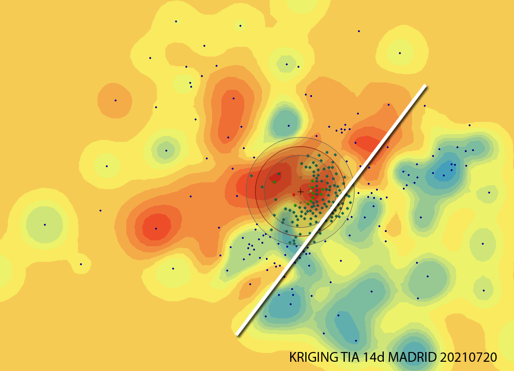
Analizando la incidencia en Madrid, a día de hoy (20210721) estas Zonas Básicas de Salud están entre las 20 más altas y preocupantes, por encima de los 780 casos por cada 100,000 en los últimos 14 días. Alguien intuye algún tipo de correlación?, Yo, sí.
Tag Archives: geografía
Seminario motivacional en el Máster Tecnologías de la Información Geográfica de la UAH
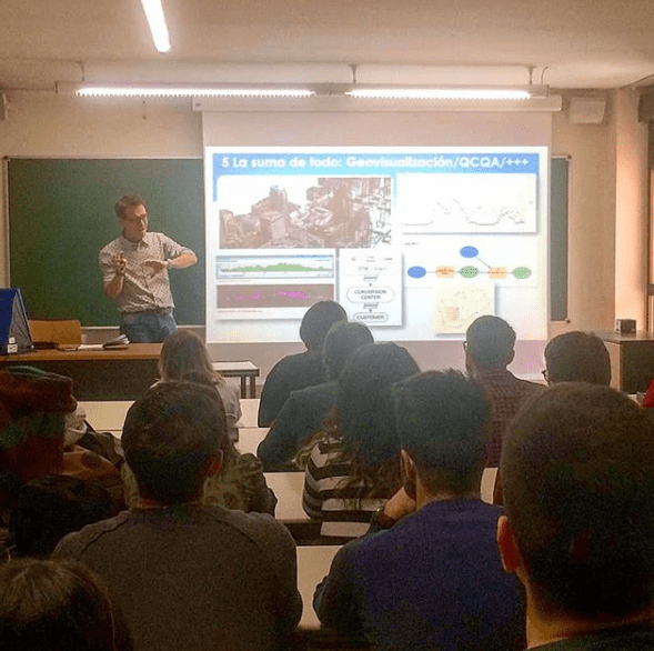
Esta vez me tocó impartir el seminario motivacional “Geógrafos en tiempos de GIS” en el entorno del Máster de Tecnologías de la Información Geográfica. Yo encantado pues este mismo máster lo cursó yo hace ya doce años (wow, time flies, el tiempo pasa rápidamente cómo dicen!) y la verdad es que me encantó hacerlo.
Seminarios motivacionales para (quizá) futuros Geógrafos

La idea era mostrar el día a día del trabajo de un Geógrafo cualquiera (yo) y el recorrido que me ha llevado hasta aquí. El porqué de la elección de la carrera, los diferentes trabajos, las influencias de otros trabajos a priori sin conexión, el día a día actual, etc.
La simbolización, las leyendas de los mapas y la prensa española

Un periodista, un diseñador, un influencer… muy guay pero para hacer los mapas, preguntad a un Geógrafo. Cada vez es más fácil usar servicios web con cartografía precargada tipo CARTO o MAPBOX pero esto no es suficiente si lo que queremos es comunicar un fenómeno o un dato de manera correcta.
La geografía española (con minúsculas)
Aquí la ‘convesación’ via twitter con el presentador de TVE Jacob Petrus. Me quejé de que se mencionara dentro de una frase, como tantas veces hemos oído, en radio y televisión, la expresión ‘La geografía española…’ refiriéndose a España en general. Lo que me indignó fue que Jacob Petrus es Geógrafo además de presentador generalistaContinue reading “La geografía española (con minúsculas)”
Visualization will endure these difficult years of CRISIS!!
I have already worked as a building cleaner, data capture operator, copywriter, photographer, graphic designer, video editor, technical salesman… and seriously, I think i’m too old to make a living in something else now… GIS has been working for me the last 8 years and i want to stay like this!!!:-) I have just read inContinue reading “Visualization will endure these difficult years of CRISIS!!”
Data acquisition: How do I know if this river is been well acquired?
I’ve already entered my river but my imagery was in 2D so… was it well acquired?… First of all, I import my shape (shp) file into Global Mapper (what a great sofware!) and export my vector file as a KML. Import my river.kml file into my brand new Google Earth 5.2 or just double-click itContinue reading “Data acquisition: How do I know if this river is been well acquired?”
Map24.com; My favorite route planner!
My very good friend Fernando (a spanish/english like friend of mine:-)) introduced me this magnificent route planner he was using at that moment (three years ago!!!!)… map24.com had a very interesting 3D engine, very easy to use and very reliable… I’ve been using it since but it has never been one of the most famousContinue reading “Map24.com; My favorite route planner!”
More of my 3D video edited scenarios.
Please, dont forget to turn on your speakers. Even if i first used a different score and Youtube’s elfs told me not to use it (because of copyright authoring) I have chosen this music from their stuff and this is what I finally got… Hope you like it. Alberto BA Geography MSc GIS and RemoteContinue reading “More of my 3D video edited scenarios.”
Some of my 3D scenarios
Barcelona (Spain), Winnipeg (Canada), Las Vegas (USA), Moscow (Russia), Durban (South Africa), Vancouver (Canada) and Tokyo (Japan)… these were some of my Terrain view’s 3D scenarios published by Computamaps, a South African company I worked in not so long ago. By the way it was one of my best professional experiences ever… I enjoyed joiningContinue reading “Some of my 3D scenarios”
