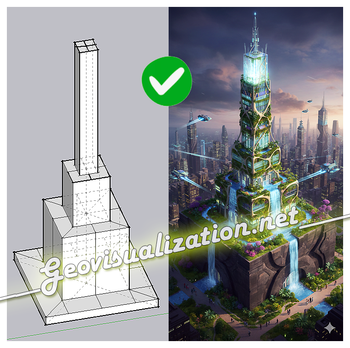
The exercise shows how a simple SketchUp 3D volume, defined solely by its basic geometry, can be transformed into a complex architectural proposal. Starting from the initial schematic model, the system interprets proportions, levels, and shapes, and converts them into a fully developed building, complete with textures, vegetation, lighting, and an urban context
Category Archives: sketchup
Consultoría e ideología: Manual de estupidez

Yo soy un humilde Geógrafo, además soy alguien curioso al que no le importa meterme en mil fregados por las razones más variadas, que ha trabajado y trabaja como tal pero también como diseñador, como fotógrafo o como comercial. He trabajado con obreros, con arquitectos, porteros de fincas, con dibujantes, con consultores de todos losContinue reading “Consultoría e ideología: Manual de estupidez”
Change detection – Detección de cambios en polígonos

THE PROCEDURE: Centroids of buildings; Spatial join showing presence-absence, considering a 10m accuracy threshold, meaning if the centroid has not moved more than 10m, its the same building. If the centroid in 2012 is not in 2014, its considered as demolished. If a new centroid appears its considered new building.
Analyse des emplacements réservés à la livraison sur voirie: NANTES
*Désole pour mon français, si vous voulez on peut parler en anglais ou espagnol. La première chose qu’il faut faire c’est télécharger le jeu de données au site: http://data.paysdelaloire.fr/donnees/ Thématique : Mobilité Le jeu propose la géo-localisation des emplacements réservés à la livraison sur voirie dans un secteur limité de la ville de Nantes. Ces aires permettentContinue reading “Analyse des emplacements réservés à la livraison sur voirie: NANTES”
Visualization will endure these difficult years of CRISIS!!
I have already worked as a building cleaner, data capture operator, copywriter, photographer, graphic designer, video editor, technical salesman… and seriously, I think i’m too old to make a living in something else now… GIS has been working for me the last 8 years and i want to stay like this!!!:-) I have just read inContinue reading “Visualization will endure these difficult years of CRISIS!!”
Solar + Shadows analysis on Rue Massillon, Nantes (France)
This is the beautiful building in from of my house in Nantes… Let’s model it first using Sketchup. Also I have used a non standard style only for visualization purposes… If we have the North behind us this means we are going to have a lot of light… but so far we are just guessing… Now weContinue reading “Solar + Shadows analysis on Rue Massillon, Nantes (France)”
Shadow analysis en Puerta de Arganda, Madrid.
Hoy publico en español puesto que los datos son en español y yo soy español:-) but if you guys have any doubt dont hesitate to ask… even if you are french I will be around to answer you back “en français”, quand même !!!. La idea era hacer un estudio de sombras de para mi propio usoContinue reading “Shadow analysis en Puerta de Arganda, Madrid.”
On va déménager alors… Analyse solaire !!!
Ma copine et moi on va nous déménager très bientôt alors il faut faire une analyse solaire. Nantes, la ville ou on habite est connue dans le monde entier pour ses niveaux de pluie, n’importe que ce soit été, printemps… meme si France Météo a dit qu’il va faire BEAU… A Nantes ça ne marcheContinue reading “On va déménager alors… Analyse solaire !!!”
Vulnérabilité de la population – Analyse SIG
An ancien analyse accompli il y a long temps mais toujours d’actualité. En espagnol.
Architectural models and some fun
I started sketching this building across the street and decided to include some funny pseudo 3D pictures of my girlfriend and myself… Architectural modelling is easy using Sketch-up. This model took me about 5 hours work (during the weekend, shame!), using components, texturing, handling scenes and exporting/editing Video. Hope you guys like it.
