How about a quick visualization of tweets in CartoDB? Hey guys, the way we used to visualize is changing on a daily basis so it’s time to catch up!!!. Let’s add a timestamp and play!! We will take a look at this dataset in depth shortly so be aware of our schedule! Regards, Alberto C.MScContinue reading “Visualizing Tweets!”
Category Archives: negocios/business
Descargas del CNIG. Open Source bien hecho!

Hola amigos del GIS, Por motivos de trabajo que no vienen al caso, he tenido que bucear de manera sistemática la web de descargas del CNIG. http://centrodedescargas.cnig.es/CentroDescargas/inicio.do Una maravilla. Por motivos que tampoco viene al caso, he de hacer esto mismo de vez en cuando en todos los Institutos cartográficos del mundo y el delContinue reading “Descargas del CNIG. Open Source bien hecho!”
Risk exposure. Geoprocessing using Open Source Data!! Next steps!!
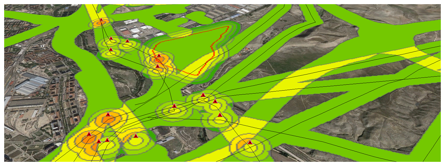
Now that we have completed a first example, let’s continue with a real-world one. Its important working on a Data Model to define what we understand as a Risk and how important this is. Meaning. High voltage power lines are an actual risk but the closer we are, i guess the bigger the risk is, meaning i.e 3 if we are within 50m and 1 if we are 150m away… It’s only a guess.
Comparing France Meteo and Spain Meteo from the visualization point of view
After living in France for four years i have to tell i am always aware of Meteo information on TV (well, i live in Brittany, i guess this makes sense!). It was the same in Spain or anywhere else in the world where i had lived and the reason why is i have always lovedContinue reading “Comparing France Meteo and Spain Meteo from the visualization point of view”
Remote Sensing, Photogrammetry, Lidar and Landuse IGN Spain
A few more lines for leting you know again that i passed this other course just now in Instituto Geográfico of Spain (IGN). Remote Sensing, Photogrammetry, Lidar and Landuse, a comprehensive 40h update on relevant information i need tu use on a daily basis. This ‘update’ helps me to better understand what i am working with andContinue reading “Remote Sensing, Photogrammetry, Lidar and Landuse IGN Spain”
La geografía española (con minúsculas)
Aquí la ‘convesación’ via twitter con el presentador de TVE Jacob Petrus. Me quejé de que se mencionara dentro de una frase, como tantas veces hemos oído, en radio y televisión, la expresión ‘La geografía española…’ refiriéndose a España en general. Lo que me indignó fue que Jacob Petrus es Geógrafo además de presentador generalistaContinue reading “La geografía española (con minúsculas)”
PISA report SPAIN 2012 by Comunidades Autónomas Trends North-South and West-East
I wanted to take advantage of the latest ‘advanced course on Statistical Analysis’ followed in the spanish IGN and show you how North-South and West-East trends impact on this report. As you can see, the higher the values, the most likely to be in the North and the East of the country. This doesn’t meanContinue reading “PISA report SPAIN 2012 by Comunidades Autónomas Trends North-South and West-East”
Analyse des emplacements réservés à la livraison sur voirie: NANTES
*Désole pour mon français, si vous voulez on peut parler en anglais ou espagnol. La première chose qu’il faut faire c’est télécharger le jeu de données au site: http://data.paysdelaloire.fr/donnees/ Thématique : Mobilité Le jeu propose la géo-localisation des emplacements réservés à la livraison sur voirie dans un secteur limité de la ville de Nantes. Ces aires permettentContinue reading “Analyse des emplacements réservés à la livraison sur voirie: NANTES”
Cool data. What is this?
What is this ‘cool data‘ all about?. When i got my degree in Geography (about 15 years ago) it didn’t make sense at all being interested in something like graphic design, photography, video and all this stuff… but not only interested in my leisure time but also for taking advantage of it, getting a lifeContinue reading “Cool data. What is this?”
Coverage map video over Bogotá, Colombia
A few months ago i prepared some scenarios over the city of Bogotá. Hope you guys like it.
