
Cada vez que corría por esta maravillosa ciudad, lo grababa con la aplicación Runkeeper, así que he superpuesto todas las ocasiones para ver dónde exactamente se concentran las rutas que más he usado y las zonas por las que he pasado más veces. Esto es lo mal de concentrar en la misma persona alguien alContinue reading “Running en Nantes”
Category Archives: GIS / SIG
Réalisation du carte de densité pour vérifier Localisation des colonnes aériennes de Nantes Métropole

Localisation et caractéristiques des colonnes d’apport volontaire aériennes de Nantes Métropole utilisées pour la collecte des déchets. Outil de visualisation Global Mapper 17 Format SHP champ: VOLUME http://data.paysdelaloire.fr/donnees/detail/localisation-des-colonnes-aeriennes-de-nantes-metropole/ Ces colonnes sont implantées sur l’ensemble du territoire et sont destinées à la collecte du verre et des emballages recyclables (papier, carton, plastique). C’est genial jouer unContinue reading “Réalisation du carte de densité pour vérifier Localisation des colonnes aériennes de Nantes Métropole”
Visualizing Tweets!
How about a quick visualization of tweets in CartoDB? Hey guys, the way we used to visualize is changing on a daily basis so it’s time to catch up!!!. Let’s add a timestamp and play!! We will take a look at this dataset in depth shortly so be aware of our schedule! Regards, Alberto C.MScContinue reading “Visualizing Tweets!”
Creating value through Open Data

The benefits of Open Data are diverse and range from improved efficiency of public administrations, economic growth in the private sector to wider social welfare (Source: http://www.europeandataportal.eu/) Performance can be enhanced by Open Data and contribute to improving the efficiency of public services. Greater efficiency in processes and delivery of public services can be achieved thanks toContinue reading “Creating value through Open Data”
Comparación de DTM usando Global Mapper 17.0.1

Comparar, primero visualmente y después cuantitativamente dos DTM. Por un lado elegimos una fuente muy usual, SRTM con un DTM derivado de Fotogrametría Stereo.
Descargas del CNIG. Open Source bien hecho!

Hola amigos del GIS, Por motivos de trabajo que no vienen al caso, he tenido que bucear de manera sistemática la web de descargas del CNIG. http://centrodedescargas.cnig.es/CentroDescargas/inicio.do Una maravilla. Por motivos que tampoco viene al caso, he de hacer esto mismo de vez en cuando en todos los Institutos cartográficos del mundo y el delContinue reading “Descargas del CNIG. Open Source bien hecho!”
Risk exposure. Geoprocessing using Open Source Data!! Next steps!!
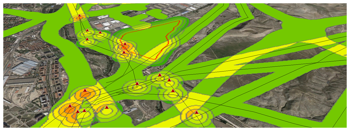
Now that we have completed a first example, let’s continue with a real-world one. Its important working on a Data Model to define what we understand as a Risk and how important this is. Meaning. High voltage power lines are an actual risk but the closer we are, i guess the bigger the risk is, meaning i.e 3 if we are within 50m and 1 if we are 150m away… It’s only a guess.
Risk exposure. First steps

Knowing how to geoprocess features is key if what we want is assesing risk exposure. What’s a risk? Which are the risks? Where are the risks? How important a risk is?
Jugando con CartoDB

Hace ya mucho tiempo que he oído hablar de CartoDB y que vengo practicando en su página web a visualizar bases de datos sencillas. Crea una cuenta Incorpora tus datos o tómalos de la galería Selecciona en modo datos la columna que quieres simbolizar/visualizar Conviértela en NUMBER si estuviera en STRING Selecciona en modo mapaContinue reading “Jugando con CartoDB”
Change detection – Detección de cambios en polígonos

THE PROCEDURE: Centroids of buildings; Spatial join showing presence-absence, considering a 10m accuracy threshold, meaning if the centroid has not moved more than 10m, its the same building. If the centroid in 2012 is not in 2014, its considered as demolished. If a new centroid appears its considered new building.
