
This GIS study applies Geographically Weighted Regression (GWR) to investigate the spatial relationship between Purchasing Power Index (PPI) and the distribution of gambling-related retail establishments within the city of Madrid. My aim is to account for spatially varying relationships driven by local urban contexts, under the assumption that the relationship between socioeconomic conditions and the presence of gambling venues varies across urban space. My hypothesis is that the socioeconomic conditions of the urban fabric can be a breeding ground for the location of betting shops, or in other words, I am attempting to Detect Urban Vulnerability to Gambling Harm.
Tag Archives: spatial analysis
500 entrenos, checked!

Hoy es un día importante para mí, desde que comencé a correr el 14 de agosto de 2014 he llegado hoy hasta los 5,500km (más exactamente 5,499km) o lo que es lo mismo, antes de fin de año, si no hay más sorpresas (ya han sido suficientes este año) estaré llegando a Teherán, la capital de Irán.
Allocation analysis: Attaching customers to facilities
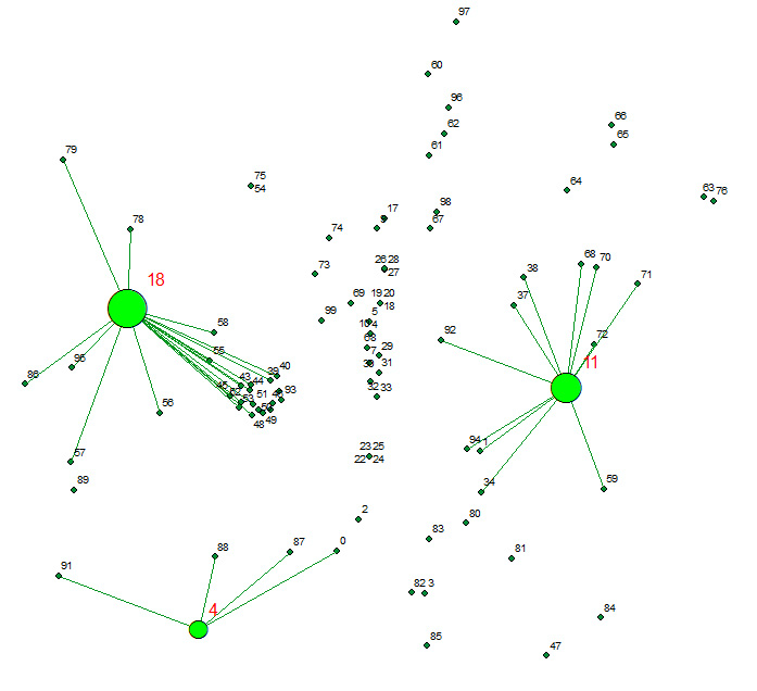
Allocates a set of demand points (Customers) to user specified number of supply points (Facilities) out of a Facilities point dataset based on the Euclidian distance between the Customers and Facilities.
Descargas del CNIG. Open Source bien hecho!

Hola amigos del GIS, Por motivos de trabajo que no vienen al caso, he tenido que bucear de manera sistemática la web de descargas del CNIG. http://centrodedescargas.cnig.es/CentroDescargas/inicio.do Una maravilla. Por motivos que tampoco viene al caso, he de hacer esto mismo de vez en cuando en todos los Institutos cartográficos del mundo y el delContinue reading “Descargas del CNIG. Open Source bien hecho!”
Advanced Thematic Cartography IGN Spain
A few lines for leting you know i passed this course last year 2013 in Instituto Geográfico of Spain (IGN). Spatial analysis, Spatial stats, proper simbolization, data mining and geovisualization. A very interesting 40h online course that helps me on a daily basis to be able to show geodata in a more professional way. BecauseContinue reading “Advanced Thematic Cartography IGN Spain”
