De nuevo no voy a hacer muchos comentarios porque las imágenes hablan por sí mismas, simplemente muestro para ver con un poco de perspectiva en el futuro. En resumen, las Tasa sube sin parar, no parece que la variante Omicrón sea grave pero sí lo suficiente como para todavía provocar algunas muertes, en todo casoContinue reading “Tracking COVID19 TIA 14d a 20220111”
Tag Archives: geography
Relación entre Tasa de Incidencia y Dinero en Madrid a 20210720 (COVID19)
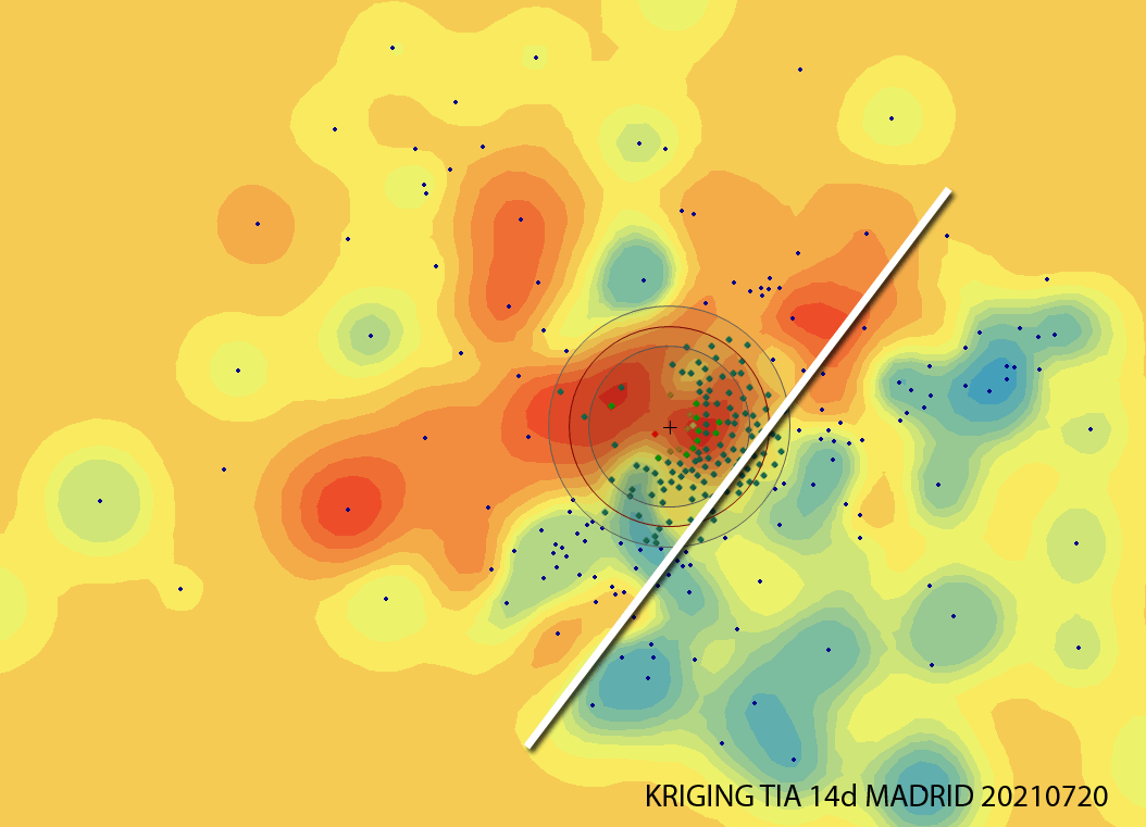
Analizando la incidencia en Madrid, a día de hoy (20210721) estas Zonas Básicas de Salud están entre las 20 más altas y preocupantes, por encima de los 780 casos por cada 100,000 en los últimos 14 días. Alguien intuye algún tipo de correlación?, Yo, sí.
Seminario motivacional en el Máster Tecnologías de la Información Geográfica de la UAH
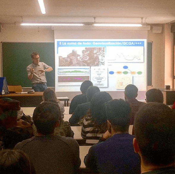
Esta vez me tocó impartir el seminario motivacional “Geógrafos en tiempos de GIS” en el entorno del Máster de Tecnologías de la Información Geográfica. Yo encantado pues este mismo máster lo cursó yo hace ya doce años (wow, time flies, el tiempo pasa rápidamente cómo dicen!) y la verdad es que me encantó hacerlo.
Visualizing Tweets!
How about a quick visualization of tweets in CartoDB? Hey guys, the way we used to visualize is changing on a daily basis so it’s time to catch up!!!. Let’s add a timestamp and play!! We will take a look at this dataset in depth shortly so be aware of our schedule! Regards, Alberto C.MScContinue reading “Visualizing Tweets!”
Cheers! Geovisualization.net has just been released!
Helo everybody. Geovisualization.net has just been released. Hope you like it.
La geográfica cabecera de ‘Up in the air’ con George Clooney
Para alguien que maneja mapas a diario es una sorpresa interesante cruzarse con esta cabecera de la película de Jason Reirman protagonizada por George Clooney ‘Up in the air’. Nubes, campos de cultivo, ciudades en 2D, 3D. Qué bien he elegido mi profesión:-) Para alguien que viaja mucho, salvando las distancias, este vídeo, también delContinue reading “La geográfica cabecera de ‘Up in the air’ con George Clooney”
Visualization will endure these difficult years of CRISIS!!
I have already worked as a building cleaner, data capture operator, copywriter, photographer, graphic designer, video editor, technical salesman… and seriously, I think i’m too old to make a living in something else now… GIS has been working for me the last 8 years and i want to stay like this!!!:-) I have just read inContinue reading “Visualization will endure these difficult years of CRISIS!!”
County of Scotland (North Carolina, US) GIS Cartography
One more video i recorded long ago on geoprocessing Cartography. Landuse, DTM, etc. Hope you like it.
Visualizing LAS LIDAR data with sketch-up
While trying to figure out the way to get a 3D model from raw Lidar data, I first opened my LAS file in Global Mapper, exported it to DXF, imported then into Sketch-up and after recording a few scenes, I saved the animation… this is it!. Alberto
Using Excel to calculate the RMSE for LiDAR vertical ground control points

The height accuracy of the collected LiDAR data can be verified by comparing with independently surveyed ground control points on hard, flat, open surfaces. It is essentially just calculating the height differences for all the control points and then determining the height root mean squared error (RMSE) or differences. Most LiDAR processing software have the reporting function built-in. However, plain Microsoft Excel can also do the job (except for extracting the elevation from the LiDAR data).
