sa mejora drásticamente, una incidencia 10 veces menor (de media) que la de hace solo dos meses, que llegó a algunos máximos en determinadas ZBS a una incidencia de 4,500 casos por 100,000 habitantes… La presión en la calle baja levemente, ya se permite desde hace un par de semanas ir sin mascarilla por la calle y se comenta que la semana que viene probablemente se quitarán las mascarillas en interiores (qué ganas!).
Tag Archives: geografía
Tracking COVID19 TIA 14d a 20220125
La cosa mejora levemente… Una visión con un poco más de perspectiva de los últimos meses (desde Sptiembre 2020) Fuente: https://datos.comunidad.madrid/catalogo/dataset/covid19_tia_zonas_basicas_saludhttps://www.comunidad.madrid/servicios/salud/coronavirushttps://comunidadmadrid.maps.arcgis.com/apps/PublicInformation/index.html?appid=7db220dc2e0a40b4a928df661a89762e
Tracking COVID19 TIA 14d a 20220111
De nuevo no voy a hacer muchos comentarios porque las imágenes hablan por sí mismas, simplemente muestro para ver con un poco de perspectiva en el futuro. En resumen, las Tasa sube sin parar, no parece que la variante Omicrón sea grave pero sí lo suficiente como para todavía provocar algunas muertes, en todo casoContinue reading “Tracking COVID19 TIA 14d a 20220111”
Relación entre Tasa de Incidencia y Dinero en Madrid a 20210720 (COVID19)
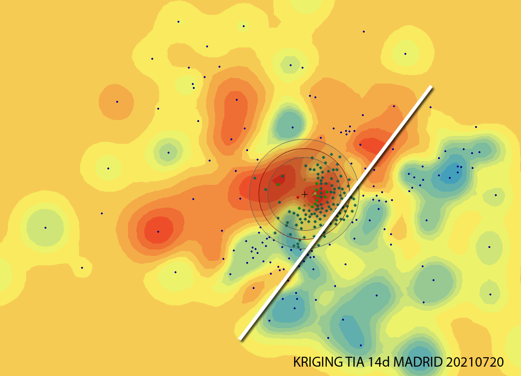
Analizando la incidencia en Madrid, a día de hoy (20210721) estas Zonas Básicas de Salud están entre las 20 más altas y preocupantes, por encima de los 780 casos por cada 100,000 en los últimos 14 días. Alguien intuye algún tipo de correlación?, Yo, sí.
Seminario motivacional en el Máster Tecnologías de la Información Geográfica de la UAH
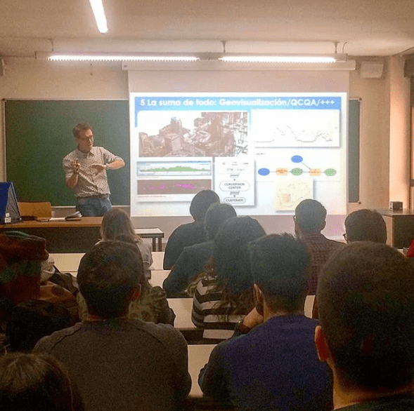
Esta vez me tocó impartir el seminario motivacional “Geógrafos en tiempos de GIS” en el entorno del Máster de Tecnologías de la Información Geográfica. Yo encantado pues este mismo máster lo cursó yo hace ya doce años (wow, time flies, el tiempo pasa rápidamente cómo dicen!) y la verdad es que me encantó hacerlo.
Seminarios motivacionales para (quizá) futuros Geógrafos

La idea era mostrar el día a día del trabajo de un Geógrafo cualquiera (yo) y el recorrido que me ha llevado hasta aquí. El porqué de la elección de la carrera, los diferentes trabajos, las influencias de otros trabajos a priori sin conexión, el día a día actual, etc.
La simbolización, las leyendas de los mapas y la prensa española

Un periodista, un diseñador, un influencer… muy guay pero para hacer los mapas, preguntad a un Geógrafo. Cada vez es más fácil usar servicios web con cartografía precargada tipo CARTO o MAPBOX pero esto no es suficiente si lo que queremos es comunicar un fenómeno o un dato de manera correcta.
La geografía española (con minúsculas)
Aquí la ‘convesación’ via twitter con el presentador de TVE Jacob Petrus. Me quejé de que se mencionara dentro de una frase, como tantas veces hemos oído, en radio y televisión, la expresión ‘La geografía española…’ refiriéndose a España en general. Lo que me indignó fue que Jacob Petrus es Geógrafo además de presentador generalistaContinue reading “La geografía española (con minúsculas)”
Visualization will endure these difficult years of CRISIS!!
I have already worked as a building cleaner, data capture operator, copywriter, photographer, graphic designer, video editor, technical salesman… and seriously, I think i’m too old to make a living in something else now… GIS has been working for me the last 8 years and i want to stay like this!!!:-) I have just read inContinue reading “Visualization will endure these difficult years of CRISIS!!”
Data acquisition: How do I know if this river is been well acquired?
I’ve already entered my river but my imagery was in 2D so… was it well acquired?… First of all, I import my shape (shp) file into Global Mapper (what a great sofware!) and export my vector file as a KML. Import my river.kml file into my brand new Google Earth 5.2 or just double-click itContinue reading “Data acquisition: How do I know if this river is been well acquired?”
