La cosa mejora levemente… Una visión con un poco más de perspectiva de los últimos meses (desde Sptiembre 2020) Fuente: https://datos.comunidad.madrid/catalogo/dataset/covid19_tia_zonas_basicas_saludhttps://www.comunidad.madrid/servicios/salud/coronavirushttps://comunidadmadrid.maps.arcgis.com/apps/PublicInformation/index.html?appid=7db220dc2e0a40b4a928df661a89762e
Tag Archives: sig
Tracking COVID19 TIA 14d a 20220111
De nuevo no voy a hacer muchos comentarios porque las imágenes hablan por sí mismas, simplemente muestro para ver con un poco de perspectiva en el futuro. En resumen, las Tasa sube sin parar, no parece que la variante Omicrón sea grave pero sí lo suficiente como para todavía provocar algunas muertes, en todo casoContinue reading “Tracking COVID19 TIA 14d a 20220111”
Subida increíble COVID-19 tasa de incidencia 14d Navidad 2021-Año nuevo 2022!!!

Cifras realmente alarmantes no porque estén generando un aumento de presión hospitalaria (menos mal!) sino porque son las cifras de contagios más altas desde el comienzo de la pandemia, hace unos 20 meses. Incluso un servidor se ha contagiado y escribe estas líneas desde el ostracismo de un aislamiento dolorosísimo en las peores fechas del año. Esta gráfica muestra cómo se llegan a multiplicar por treinta las incidencias en dos meses…
Desarrollo urbanístico en Madrid capital desde mediados del S.XIX hasta hoy
Todos los edificios actuales de Madrid presentes en la base de datos de Catastro a día de hoy tienen su año de creación. Esto es un mapa que muestra -por décadas- dónde se concentraba la mayor parte de ese desarrollo urbanístico. Por ejemplo en los años 20 fue en el Barrio de Salamanca, en losContinue reading “Desarrollo urbanístico en Madrid capital desde mediados del S.XIX hasta hoy”
Relación entre Tasa de Incidencia y Dinero en Madrid a 20210720 (COVID19)
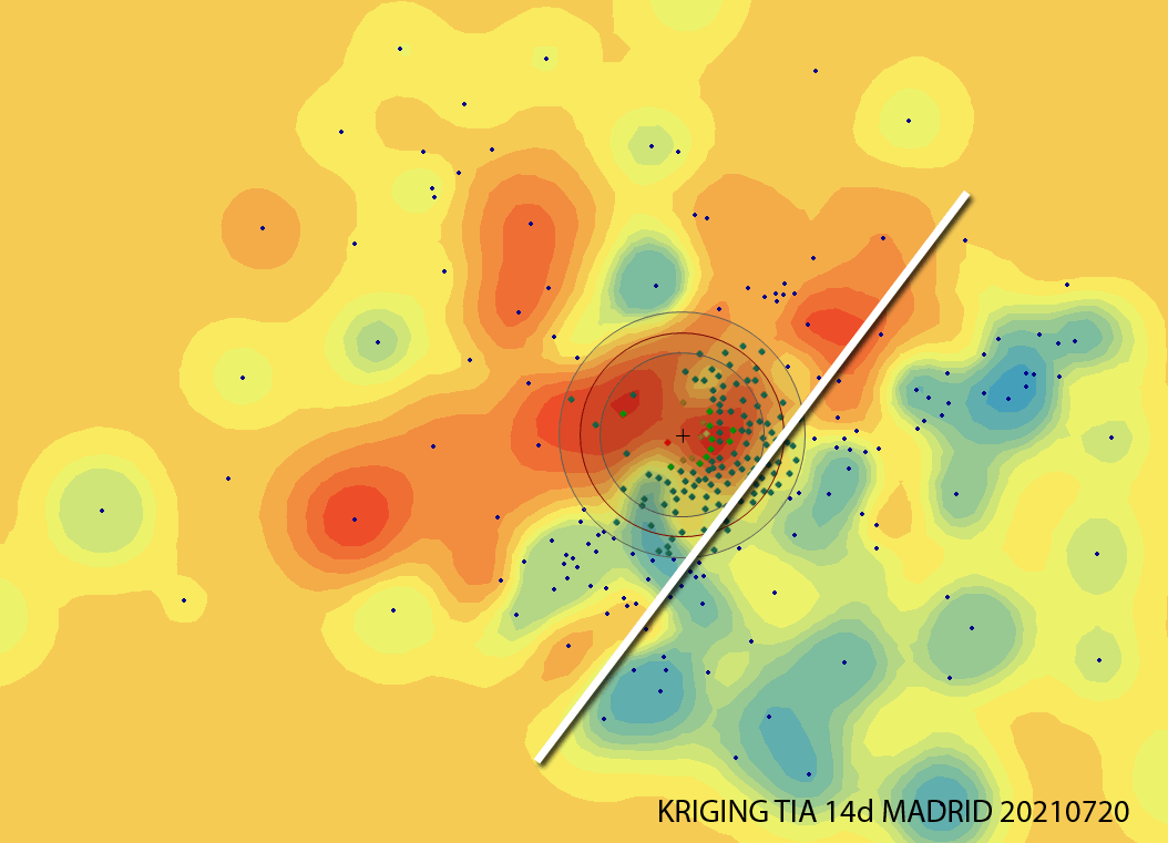
Analizando la incidencia en Madrid, a día de hoy (20210721) estas Zonas Básicas de Salud están entre las 20 más altas y preocupantes, por encima de los 780 casos por cada 100,000 en los últimos 14 días. Alguien intuye algún tipo de correlación?, Yo, sí.
Análisis TIA 14d COVID en Madrid a 20210512

Dudé hasta el último momento de publicar este mapa y es que la falta de criterio hace que se tomen elecciones equivocadas, como pensar que la pandemia ha finalizado cuando ni mucho menos es el caso. Ayer mismo murieron 30 personas en Madrid. 30 familias destrozadas.
Tendencia de la Tasa de Incidencia Acumulada en Madrid a 20210325

Comparando siempre la semana en curso con la anterior, midiendo las variaciones porcentuales y viendo hacia dónde vamos. Como se aprecia, cada vez hay más ZBS (Zonas Básicas de Salud) donde los datos de la semana presente son peores que los anteriores, lo que no pinta muy bien!.
¡Cartografía en estado puro! Análisis COVID19 (Tasa de Incidencia acumulada 14d) por Zonas Básicas de Salud en la Comunidad de Madrid, España

asa de Incidencia Acumulada para cada una de las 287 Zonas Básicas de Salud de Madrid, definiendo rangos y colores correctos de visualización y luego un poco de Photoshop aquí y allá y voilá!
CORONOVIRUS ANÁLISIS MADRID (updated 20201029)

Según el enfoque, los resultados parecen ambiguos. En todo caso, cuando no está claro el tema, lo mejor es la precaución y en la Comunidad de Madrid podríamos tener en el mejor de los casos a una suicida como presidenta, Isabel “DEATH” Ayuso y sus decisiones no parecen contradecir esto. Lo peor es que detrás de sus decisiones están muchos millones de personas, no solo en Madrid.
Nuevo estado de Alarma en Madrid. ¿Era necesario?

En estas últimas dos semanas, ya pueden pintarlo como quieran en la Comunidad de Madrid pero la Tasa de Incidencia Acumulada 14d por encima de 750 (el índice que querían usar a cambio de las medidas impuestas por el Gobierno Central) afectaba hace dos semanas a 2,2 millones mientras que ahora lo hace a 2,9 millones. ¿Hay que actuar?. ¡La respuesta es YA!
