
While initially puzzling, the abnormally high values observed in early winter via the Ulyssys Water Quality Viewer (UWQV), based on Sentinel-2 surface reflectance, seemed at first glance to result from remote sensing artifacts. During winter months, low solar elevation typically introduces radiometric distortions — notably increased atmospheric path radiance and longer photon path lengths — which can bias water quality retrievals, particularly in optically dark or complex inland waters. These effects are often compounded by known limitations in atmospheric correction algorithms under low-illumination conditions, especially when residual aerosol loading, adjacency effects from snow-covered surroundings, or sub-pixel ice contamination are present. Furthermore, the empirical models embedded in UWQV are generally not seasonally calibrated, and may overreact to slight shifts in reflectance ratios driven by non-biological phenomena.

Summarizing, potential issues we need to first approach:
A Atmospheric Correction Limitations
1 In winter, low sun angles, higher aerosol loads, and thin cirrus contamination challenge atmospheric correction algorithms. 2 Water bodies have very low reflectance compared to land, so any residual atmospheric effects disproportionately affect them. And 3, In turbid or eutrophic systems, bottom reflection and adjacency effects can also contaminate the signal.
B Optical Properties and Solar Zenith Angle
During winter months, especially at mid to high latitudes, the solar zenith angle increases significantly (i.e., the sun is lower in the sky). This results in:
1 Reduced surface irradiance, altering the light–water interaction and increasing the path length through the atmosphere. 2, greater Rayleigh scattering and atmospheric path radiance, especially in blue bands (e.g., B2, B3), which are critical for water quality algorithms. And 3, altered reflectance ratios, which can skew bio-optical models that estimate turbidity, chlorophyll-a, and CDOM.
However, in light of recent meteorological conditions in the study area — specifically the occurrence of exceptionally heavy rainfall events in the La Safor region of Valencia — a more grounded explanation emerges, rooted in hydrological and sediment dynamics rather than in sensor or algorithmic artifacts.
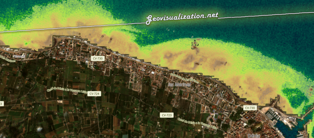
Intense precipitation, particularly when sustained over short temporal windows, can trigger substantial runoff from surrounding basins into coastal or inland water bodies. In Mediterranean regions such as La Safor, where orographic effects and land cover can exacerbate surface flow, such events are well known to introduce significant loads of suspended sediments, organic debris, and colored dissolved organic matter (CDOM) into aquatic systems. These inputs alter the optical properties of the water column by enhancing backscatter and absorption, particularly in the red and blue spectral ranges. Consequently, satellite-derived turbidity proxies — many of which rely on ratios involving Bands 3 (green) and 4 (red) or Bands 2 and 3 — respond sensitively to these shifts, yielding elevated values that genuinely reflect post-rainfall sediment plumes rather than sensor-induced noise.

In this specific case, the surge in water quality parameter estimates at the onset of winter is best understood as a physical signal of increased particulate and dissolved matter loadings following hydrometeorological disturbances, rather than a byproduct of atmospheric correction errors or low sun angle artifacts. This reinforces the importance of integrating auxiliary datasets — such as precipitation records, river discharge measurements, and land use change dynamics — when interpreting satellite-derived water quality metrics, especially in regions with episodic climatic regimes.
Ultimately, while radiometric caution is always advisable during winter acquisitions, attributing anomalies solely to algorithmic noise without considering watershed-level processes may obscure genuine environmental dynamics. The intersection of optical remote sensing with event-driven hydrology highlights the power and also the interpretative challenge of Earth Observation in complex freshwater and transitional environments.

The process unfolds as follows:
- High rainfall triggers overland flow and stream discharge, carrying sediments, organic detritus, and CDOM into receiving water bodies.
- Increased turbidity alters water-leaving reflectance (R_rs)—particularly in visible bands—leading to elevated backscatter.
- Satellite indices sensitive to TSM (Total Suspended Matter), such as green/red ratio or absolute reflectance thresholds, then detect plumes as bright anomalies offshore.
These reflectance shifts are not artifacts but a genuine optical signature of sediment dispersal following hydro-meteorological events.
https://custom-scripts.sentinel-hub.com/sentinel-2/ulyssys_water_quality_viewer/
https://dataspace.copernicus.eu/
Alberto C.
Geodata analyst and d’ailleurs, La Safor region lover
