
Wildfire Emergencies Declared in Russia’s Far East Republics of Tyva, Sakha
In recent days, the Sakha region in Russia has experienced significant wildfire activity, More than 100 wildfires spanning more than 300,000 hectares are currently active. driven by a combination of extreme weather conditions and environmental factors. The fires, which have spread across vast areas of forest and tundra, have been exacerbated by unusually high temperatures and prolonged periods of drought. These conditions have led to exceptionally dry vegetation, creating an ideal fuel for the fires.
The wildfires in Sakha have released substantial amounts of carbon dioxide and other greenhouse gases into the atmosphere, contributing to global climate change. Satellite imagery has revealed extensive smoke plumes, which have affected air quality not only locally but also in distant regions. The fires have also disrupted local ecosystems, threatening biodiversity and the habitats of various wildlife species.
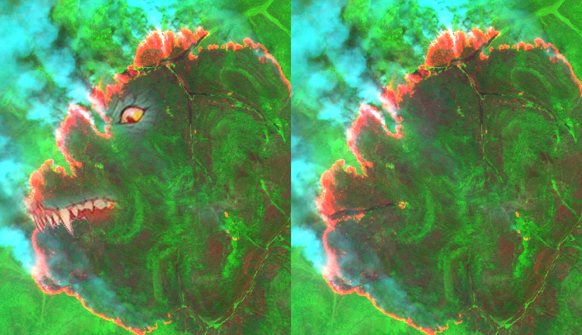
The combination of bands 12 (Short-Wave Infrared, SWIR), 11 (Short-Wave Infrared, SWIR), and 4 (Red) from Sentinel-2 imagery is commonly used for various applications, including vegetation analysis, burn scar mapping, and soil moisture monitoring. This band combination provides a unique perspective on land surface features due to the distinct reflectance properties of different materials in these spectral regions.
- Band 12 (SWIR – 2190 nm): This band is sensitive to water content in soil and vegetation. It is useful for distinguishing between dry and moist areas, as well as identifying burn scars, as charred vegetation absorbs more in this wavelength.
- Band 11 (SWIR – 1610 nm): Similar to Band 12, this band is also sensitive to water content. It helps in assessing vegetation health and detecting thermal anomalies. Its lower wavelength compared to Band 12 makes it slightly more sensitive to moisture content.
- Band 4 (Red – 665 nm): This band is part of the visible spectrum and is highly responsive to chlorophyll absorption in plants. It is essential for vegetation analysis, including calculating vegetation indices like NDVI (Normalized Difference Vegetation Index).
When combined, bands 12, 11, and 4 create a false-color composite that enhances the visibility of certain features. In this composite:
- Vegetation typically appears in shades of red and orange, with healthier, denser vegetation showing more intense red.
- Burn scars and areas with low vegetation moisture content are highlighted in dark tones, often appearing as dark brown or black.
- Bare soil and urban areas may appear in shades of cyan or blue, depending on the moisture content and material composition.
This band combination is particularly useful for monitoring post-fire landscapes, as it clearly delineates burn scars and helps in assessing the extent of fire damage. It also assists in agricultural management by providing insights into soil and crop conditions.

The combination of bands 12 (SWIR), 8 (NIR), and 4 (Red) in Sentinel-2 imagery differs from 12-11-4 primarily in the inclusion of the Near-Infrared (NIR) band instead of the second Short-Wave Infrared (SWIR) band. This change affects the image interpretation as follows:
- Band 8 (NIR – 842 nm): This band is highly sensitive to vegetation, as healthy vegetation reflects strongly in the NIR. It enhances the visibility of vegetation health and biomass.
In the 12-8-4 composite:
- Vegetation appears more vibrant in shades of red due to the strong NIR reflection.
- Burn scars and low moisture areas are still highlighted in dark tones (from Band 12).
- The overall contrast between healthy vegetation and other land features is more pronounced compared to the 12-11-4 combination.
The technical response to the wildfires has involved the deployment of firefighting personnel and equipment, including aircraft for aerial firefighting. However, the vast and remote nature of the affected areas has posed significant logistical challenges. Firefighters have had to contend with limited accessibility and resources, making it difficult to control and extinguish the fires effectively.
Advanced technologies such as remote sensing and Geographic Information Systems (GIS) have been utilized to monitor the extent and progression of the wildfires. These tools provide real-time data, helping to coordinate firefighting efforts and assess the impact on the environment. Additionally, climate models are being used to predict future wildfire risks in the region, considering ongoing climate trends.

The situation in Sakha highlights the broader issue of increasing wildfire frequency and intensity due to climate change. It underscores the need for improved forest management practices, early warning systems, and international cooperation in addressing the challenges posed by wildfires. As the fires continue to burn, the focus remains on mitigating their impact and protecting both human communities and natural ecosystems.
Please note I UNDERSTAND WHY THEY CALL THEM WILDFIRES!!
Lat: 59.87946, Lng: 136.09365 – 2023-08-10 – SENTINEL-2 Combination 12/8/4

Hope you enjoyed the post,
Regards,
Alberto C.
GIS analyst
SOURCES:
https://www.themoscowtimes.com/2024/07/01/wildfire-emergencies-declared-in-russias-far-east-republics-of-tyva-sakha-a85571
https://report.az/en/region/wildfires-cover-almost-1-million-hectares-in-russia-s-yakutia/
https://s2gm.land.copernicus.eu/
https://earthobservatory.nasa.gov/images/19770/fires-in-southern-russia
https://worldview.earthdata.nasa.gov/?v=-131.59576218628234,36.28670613252814,-110.01769405924279,46.61495853291842&z=4&ics=true&ici=5&icd=10&as=2021-08-05-T18%3A40%3A00Z&ae=2021-08-05-T22%3A30%3A00Z&l=Reference_Labels_15m,Reference_Features_15m,Coastlines_15m(hidden),MODIS_Terra_Thermal_Anomalies_Day(hidden),GOES-West_ABI_GeoColor&lg=true&tr=geostationary&al=true&av=7&ab=on
